San Cristóbal Airport
| San Cristóbal Airport | |||||||||||
|---|---|---|---|---|---|---|---|---|---|---|---|
 | |||||||||||
| Summary | |||||||||||
| Airport type | Public | ||||||||||
| Serves | Galápagos Islands, Ecuador | ||||||||||
| Location | San Cristóbal, Ecuador | ||||||||||
| Elevation AMSL | 62 ft / 19 m | ||||||||||
| Coordinates | 00°54′37″S 89°37′03″W / 0.91028°S 89.61750°W | ||||||||||
| Map | |||||||||||
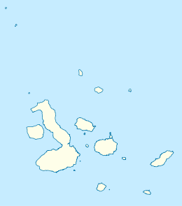 SCY Location of airport in Ecuador | |||||||||||
| Runways | |||||||||||
| |||||||||||
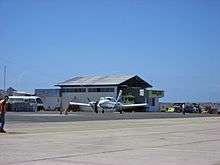
San Cristóbal Airport (IATA: SCY, ICAO: SEST) is an airport on the island of San Cristóbal, in the Galápagos Islands of Ecuador. The airport is on the southwestern end of the island, with rising terrain to the northeast. Approaches to both runways are over the ocean.
The San Cristobal non-directional beacon (Ident: SCR) and VOR-DME (Ident: SCV) are located on the field.[3][4]
Airlines and destinations
| Airlines | Destinations |
|---|---|
| Avianca Ecuador | Guayaquil, Quito |
| LATAM Ecuador | Guayaquil, Quito |
| TAME | Baltra, Guayaquil, Quito |
See also


- Transport in Ecuador
- List of airports in Ecuador
References
- ↑ Airport information for San Cristóbal at Great Circle Mapper.
- ↑ Google Maps - San Cristóbal
- ↑ San Cristobal NDB
- ↑ San Cristobal VOR
External links

- OpenStreetMap - San Cristóbal
- OurAirports - San Cristóbal
- SkyVector - San Cristóbal
- Accident history for SCY at Aviation Safety Network
- Airport information for SEST at World Aero Data. Data current as of October 2006.
- Current weather for SEST at NOAA/NWS
This article is issued from
Wikipedia.
The text is licensed under Creative Commons - Attribution - Sharealike.
Additional terms may apply for the media files.