Sam Phran District
| Sam Phran สามพราน | |
|---|---|
| Amphoe | |
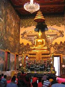 Luang Por Wat Rai Khing, principle Buddha image of Wat Rai Khing, Tambon Rai, Sam Phran District, next to Nakhon Chai Si River (Tha Chin River). | |
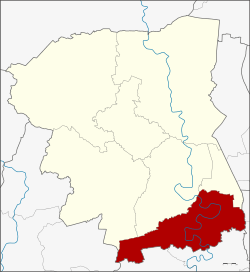 Amphoe location in Nakhon Pathom Province | |
| Coordinates: 13°43′27″N 100°13′0″E / 13.72417°N 100.21667°ECoordinates: 13°43′27″N 100°13′0″E / 13.72417°N 100.21667°E | |
| Country | Thailand |
| Province | Nakhon Pathom |
| Seat | Sam Phran |
| Area | |
| • Total | 249.347 km2 (96.273 sq mi) |
| Population (2017) | |
| • Total | 208,836 |
| • Density | 837.53/km2 (2,169.2/sq mi) |
| Time zone | UTC+7 (ICT) |
| Postal code | 73110 |
| Geocode | 7306 |
Sam Phran (Thai: สามพราน, pronounced [sǎːm pʰrāːn]) is the southernmost district (amphoe) of Nakhon Pathom Province, Thailand.
History
The district was established in 1896, then named Talat Mai District. It was renamed Sam Phran in 1917.[1]
The word Sam Phran meaning Three Hunters, refers to three hunters according to folklore, which is told in the form of oral tradition.[2]
Geography
The district is elongated in an east-west direction and neighbouring districts are (from the north clockwise) Mueang Nakhon Pathom, Nakhon Chai Si, and Phutthamonthon of Nakhon Pathom Province, Thawi Watthana and Nong Khaem of Bangkok, Krathum Baen and Ban Phaeo of Samut Sakhon Province, and Bang Phae of Ratchaburi Province.
The main water resource of the district is the large Tha Chin River or Nakhon Chai Si River which meanders through the district in a southeasterly direction.
Sam Phran District has evolved as a ribbon development of tambons (sub-districts) along Phetkasem Road, a major thoroughfare linking Bangkok with the cities of Nakhon Pathom and Kanchanaburi.
Demography
As in most of central Thailand, the people are a mix of Thai and Chinese ethnic origins. The local population also includes a large number of people who have migrated from Isan, Thailand's northeastern region, to be part of the labour force in the many factories in the area. The Sam Phran city centre is about one kilometre to the south of the Phetkasem Road at the western extremity of the district. Sampran has a very high percentage of Roman Catholic Christians.
Culture and economy
Sam Phran is well known for its large number of clothing and apparel factories, many of which work exclusively as out-sourced labour centres for famous international brands. Intensive pig farming is another major economic activity. Of the two main townships, Sam Phran City retains the aspect of a country town while Om Yai is on Phetkasem Road and is a busy shopping, business, market, and factory area, with modern facilities including malls, clinics, and hospitals.
The Tha Kham Sub-district (usually written Takham), is the centre of the Roman Catholic Christian religion in Thailand. Michael Michai Kitbunchu, Cardinal of Thailand, was born in Sam Phran and many Catholic religious institutes have their convents, monasteries, and headquarters in the area as well as Thailand's major seminary. The largest and most important installation in the Catholic enclave of Tha Kham is the campus shared by Joseph Upatham School, one of the largest combined kindergarten, primary, and secondary schools in the country. It is one of the 43 schools and colleges governed by the Education Department of Bangkok Archdiocese (EDBA). The Ban Phu Waan Pastoral Training Centre, a leading Catholic conference and convention centre is also here. There are several other large private schools in Tak Kham including St. Peter's school (mixed gender, grades K–9) also governed by the EDBA in the parish of St. Peter, a village and factory community about two kilometres from the main highway in the south of Tha Kham, and Marie Upatham, an independent Catholic school for girls in the Tha Kham village of Mor Sii.
Sam Phran is the site of the National Police Academy and numerous other colleges including St. Joseph Intertechnology College, a Catholic vocational school and teacher training centre also governed by the EDBA.
Administration
The district is divided into 16 sub-districts (tambon), which are further subdivided into 137 villages (muban). Sam Phran is a town (thesaban mueang) and Om Yai a sub-district municipality (thesaban tambon). There are a further 15 tambon administrative organizations (TAO).
| No. | Name | Thai | Villages | Pop. |
|---|---|---|---|---|
| 1. | Tha Kham | ท่าข้าม | 6 | 9,880 |
| 2. | Song Khanong | ทรงคนอง | 6 | 4,140 |
| 3. | Hom Kret | หอมเกร็ด | 6 | 8,015 |
| 4. | Bang Krathuek | บางกระทึก | 8 | 9,470 |
| 5. | Bang Toei | บางเตย | 7 | 4,016 |
| 6. | Sam Phran | สามพราน | 9 | 12,430 |
| 7. | Bang Chang | บางช้าง | 11 | 7,638 |
| 8. | Rai Khing | ไร่ขิง | 14 | 22,406 |
| 9. | Tha Talat | ท่าตลาด | 10 | 14,848 |
| 10. | Krathum Lom | กระทุ่มล้ม | 9 | 16,398 |
| 11. | Khlong Mai | คลองใหม่ | 7 | 11,326 |
| 12. | Talat Chinda | ตลาดจินดา | 11 | 7,397 |
| 13. | Khlong Chinda | คลองจินดา | 14 | 11,579 |
| 14. | Yai Cha | ยายชา | 6 | 7,102 |
| 15. | Ban Mai | บ้านใหม่ | 5 | 9,142 |
| 16. | Om Yai | อ้อมใหญ่ | 8 | 15,775 |
Places of interest
- Wat Rai Khing (วัดไร่ขิง), prominent temple of the district located on Nakhon Chai Si River (Tha Chin River)
- Rose Garden Riverside (สวนสามพราน), botanical garden and the center of authentic Thai way of life and learn about local wisdom on the Nakhon Chai Si River
- Samphran Elephant Ground And Zoo (ลานแสดงช้างและฟาร์มจระเข้สามพราน), crocodile farm and zoo, a branch of Samutprakarn Crocodile Farm and Zoo
- Royal Police Cadet Academy (โรงเรียนนายร้อยตำรวจ), the police academy under Royal Thai Police (RTP)
- Don Wai Floating Market (ตลาดน้ำดอนหวาย), notable floating market and popular tourist attraction of the province
Notable people
- Chanathip "Messi-J" Songkrasin, Thai professional footballer
- Michael Michai Kitbunchu, Cardinal of Thailand
References
- ↑ ประกาศกระทรวงมหาดไทย เรื่อง เปลี่ยนชื่ออำเภอ (PDF). Royal Gazette (in Thai). 34 (0 ก): 40–68. April 29, 1917.
- ↑ ตำนานสามพราน. yaicha.net (in Thai). December 31, 2006.
External links
- amphoe.com (Thai)