Samana Cay
Samana Cay is now an uninhabited island in the Bahamas, believed by some researchers to have been the location of Columbus's first landfall in the Americas, on October 12, 1492.[1]
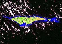
It is an islet, located in the eastern Bahamas, 22 miles (35 km) northeast of Acklins Island. About 10 miles (16 km) long and up to 2 miles (3 km) wide with an area of about 17.37 mi² (45 km²) it is bound by reefs. The verdant cay has long been uninhabited, but figurines, pottery shards, and other artifacts discovered there in the mid-1980s have been ascribed to Lucayan Indians living on the cay about the time of Christopher Columbus’ voyages.
The indigenous people of the island on which Columbus first landed called it Guanahani. Samana Cay was first proposed to be Guanahani by Gustavus Fox in 1882[2], but the predominant theory gives the honour to San Salvador Island.[3] However, in 1986 Joseph Judge of National Geographic Magazine made different calculations based on extracts from Columbus's logs, and argued for Samana Cay as the location, though his methodology has also been criticised.[4]
Samana was a name of apparent Lucayan origin (meaning "Small Middle Forest") used by the Spanish to designate one of the islands in the Bahamas. Granberry and Vesceliuus identify that island as the present-day Samana Cay.[5]
Samana Cay had a permanent population during the first half of the 20th century and the ruins of this settlement are visible on the south side of the island, near the western end. The island is now uninhabited, but residents of nearby Acklins Island visit occasionally to collect cascarilla bark, which grows in abundance on the island.
Notes
- ↑ Markham, Clements Robert (1892). Life of Christopher Columbus. London: G. Philip & Son. p. 97.
- ↑ Fox, Gustavus V. (June 1880). "An Attempt to solve the Problem of the First Landing Place of Columbus in the New World", "Report of the Superintendent of the US Coast and Geodetic Survey". Appendix No. 18. Washington, DC: Government Printing office.
- ↑ William D. Phillips Jr., 'Columbus, Christopher', in David Buisseret (ed.), The Oxford Companion to World Exploration, (Oxford: Oxford University Press, online edition 2012).
- ↑ For a brief discussion of the controversy see William D. Phillips, Jr., and Carla Rahn Phillips, The Worlds of Christopher Columbus (Cambridge and New York: Cambridge University Press, 1992), pp. 155-5.
- ↑ Julian Granberry and Gary S. Vescelius. (2004) Languages of the Pre-Columbian Antilles. The University of Alabama Press. ISBN 0-8173-5123-X p. 83
External links
Coordinates: 23°05′N 73°45′W / 23.083°N 73.750°W