Samalá River
| Samalá River | |
|---|---|
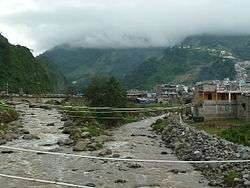 The Samalá River at Zunil | |
| Country | Guatemala |
| Physical characteristics | |
| Main source |
Sierra Madre in the Valle De Écija, San Carlos Sija 3,200 m (10,500 ft) 15°02′05″N 91°34′22″W / 15.034759°N 91.572847°W |
| River mouth |
Pacific Ocean 0 m (0 ft) 14°11′31″N 91°47′08″W / 14.191934°N 91.785450°WCoordinates: 14°11′31″N 91°47′08″W / 14.191934°N 91.785450°W |
| Length | 145 km (90 mi) |
| Discharge |
|
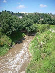
The Samalá River on the outskirts of Quetzaltenango city
The Samalá is a river in southwestern Guatemala. Its sources are in the Sierra Madre, Valle De Écija range, in the departments of Quetzaltenango and Totonicapán. From there it flows down, past the towns San Carlos Sija in the Valle De Écija, Quetzaltenango, San Cristóbal Totonicapán, Quetzaltenango, El Palmar and Zunil, through the coastal plains of Retalhuleu into the Pacific Ocean.[1]
The Samalá river basin covers a territory of 1,510 square kilometres (580 sq mi) and has a population of around 400,000 people.[2] Its proximity to the active Santa Maria and Santiaguito volcano complex, with its recurring lava and lahars flows, leads to a heightened risk of serious flooding.[3]
External links
| Wikimedia Commons has media related to Río Samalá. |
References
- ↑ INSIVUMEH. "Mapa de Cuencas y Ríos".
- ↑ INSIVUMEH. "Principales ríos de Guatemala".
- ↑ Francisco de la Caridad Viera Cepero (2003). "Geomorphology and natural hazards of the Samala river basin, Guatemala" (PDF).
This article is issued from
Wikipedia.
The text is licensed under Creative Commons - Attribution - Sharealike.
Additional terms may apply for the media files.