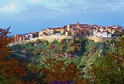
Salvitelle
| Salvitelle | |
|---|---|
| Comune | |
| Comune di Salvitelle | |
 | |
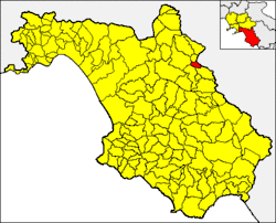 Salvitelle within the Province of Salerno | |
 Salvitelle Location of Salvitelle in Italy | |
| Coordinates: 40°36′N 15°28′E / 40.600°N 15.467°ECoordinates: 40°36′N 15°28′E / 40.600°N 15.467°E | |
| Country | Italy |
| Region | Campania |
| Province | Salerno (SA) |
| Area | |
| • Total | 9 km2 (3 sq mi) |
| Elevation | 630 m (2,070 ft) |
| Population (1 December 2009)[1] | |
| • Total | 609 |
| • Density | 68/km2 (180/sq mi) |
| Demonym(s) | Salvitellesi |
| Time zone | UTC+1 (CET) |
| • Summer (DST) | UTC+2 (CEST) |
| Postal code | 84020 |
| Dialing code | 0975 |
| ISTAT code | 065117 |
| Patron saint | San Sebastiano |
| Saint day | 20 January and the last Sunday in August |
| Website | Official website |
Salvitelle (Campanian: Salvtell) is a town and comune in the province of Salerno in the Campania region of southwestern Italy.
Geography
The municipality borders with Auletta, Buccino, Caggiano, Romagnano al Monte and Vietri di Potenza (PZ).
Monuments and Places of Interest
- Chapel of St. Sebastian (1557-1558),
- Church of SS. Rosario (1740),
- Church of the Holy Spirit (1800),
- Grassibelli Palace,
- Mucci Palace,
- Romanzi Palace,
- Briganti Palace.
References
- ↑ All demographics and other statistics from the Italian statistical institute (Istat); Dati - Popolazione residente all'1/4/2009
External links
![]()
This article is issued from
Wikipedia.
The text is licensed under Creative Commons - Attribution - Sharealike.
Additional terms may apply for the media files.