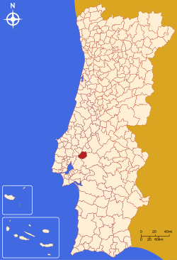
Salvaterra de Magos
| Salvaterra de Magos | |||
|---|---|---|---|
| Municipality | |||
| |||
 | |||
| Coordinates: 39°01′N 8°47′W / 39.017°N 8.783°WCoordinates: 39°01′N 8°47′W / 39.017°N 8.783°W | |||
| Country |
| ||
| Region | Ribatejo | ||
| Subregion | Lezíria do Tejo | ||
| Intermunic. comm. | Lezíria do Tejo | ||
| District | Santarém | ||
| Parishes | 4 | ||
| Government | |||
| • President | Hélder Manuel Ramalho de Sousa Esménio (PS) | ||
| Area | |||
| • Total | 243.93 km2 (94.18 sq mi) | ||
| Population (2011) | |||
| • Total | 22,159 | ||
| • Density | 91/km2 (240/sq mi) | ||
| Time zone | WET/WEST (UTC+0/+1) | ||
| Website | http://www.cm-salvaterrademagos.pt | ||

Salvaterra de Magos (Portuguese pronunciation: [ˌsaɫvɐˈtɛʁɐ ðɨ ˈmaɣuʃ]) is a municipality in the district of Santarém in Portugal. The population in 2011 was 22,159,[1] in an area of 243.93 km².[2]
The present Mayor is Hélder Manuel Ramalho de Sousa Esménio of the PS. The previous mayor Ana Cristina Pardal Ribeiro, had been the only mayor elected by the Left Bloc. The municipal holiday is Ascension Day.
Parishes
Administratively, the municipality is divided into 4 civil parishes (freguesias):[3]
References
- ↑ Instituto Nacional de Estatística
- ↑ Direção-Geral do Território Archived 2014-09-29 at Archive.is
- ↑ Diário da República. "Law nr. 11-A/2013, page 552 106" (pdf) (in Portuguese). Retrieved 30 July 2014.
External links
This article is issued from
Wikipedia.
The text is licensed under Creative Commons - Attribution - Sharealike.
Additional terms may apply for the media files.