Salkeld Hall
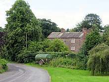
Salkeld Hall is a red sandstone Grade II* listed country house in the village of Little Salkeld, Cumbria, England. It is the original residence of the Salkeld family.
History
The current house was constructed in the late 16th century using walls from previous building(s) that stood on the site. The oldest part of the building was dated in 1967 as being from the 14th century.[1] The date of the first building to exist on the site is unknown; it is the potential location of an 'ancient castle'.[2]
Corby Castle, built from similar materials in the 14th century was also owned by the Salkeld Family. Mr George Salkeld, the last member of which to own Salkeld Hall was forced from the house at the time of the English Civil War for a 'trifling consideration'. Ownership was passed to Colonel Cholmley who built a new house on the site and before the year of 1688 it became the property of Mr Charles Smallwood. His descendant, Timothy Smallwood, Esq. sold the house to Colonel Samuel Lacy in 1790.[2]
During his occupation of the house Lacy's servant (a deserted batman) was (under instruction) responsible for the carving of Lacy's Caves and attempting to blow up the stones at Long Meg and Her Daughters with gunpowder so that the field could be ploughed. The latter is unconfirmed and according to some sources took place in 1725 before Lacy was alive. Local folklore tells that when work commenced a tremendous storm broke out overhead that caused the workmen to flee the site and abandon the work permanently.
Colonel Lacy sold the house in 1836 to Robert Hodgson, Esq. Ownership between this and the current is unknown, however in 1847 Robert Hodgson was still the reported owner and had made great improvements to the house, offices and gardens.[3]
In 1967 the house was recorded as having been divided into a number of holiday flats.
Present condition
The house is currently privately owned with no public rights of way across the land. The main part of the house is intact and occupied by the owner. What were holiday flats are now rented on contract basis and little modernisation has taken place since the 60s. A number of out buildings to the south-east of the property which at one time would have been self-contained 2 storey houses are now in ruin.
See also
References
- ↑ Historic England. "Details from image database (74279)". Images of England. Retrieved 22 April 2015.
- 1 2 "Parishes: Addingham - Aspatria', Magna Britannia: volume 4: Cumberland". 1816. p. 4-18. Retrieved 4 January 2007.
- ↑ "Mannix & Whellan, History, Gazetteer and Directory of Cumberland, 1847 -".