Saldenburg
| Saldenburg | ||
|---|---|---|
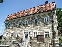 Town hall | ||
| ||
 Saldenburg Location of Saldenburg within Freyung-Grafenau district 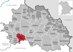 | ||
| Coordinates: 48°47′N 13°21′E / 48.783°N 13.350°ECoordinates: 48°47′N 13°21′E / 48.783°N 13.350°E | ||
| Country | Germany | |
| State | Bavaria | |
| Admin. region | Niederbayern | |
| District | Freyung-Grafenau | |
| Government | ||
| • Mayor | Herbert Gebert | |
| Area | ||
| • Total | 28.04 km2 (10.83 sq mi) | |
| Elevation | 450-570 m (−1,420 ft) | |
| Population (2017-12-31)[1] | ||
| • Total | 1,978 | |
| • Density | 71/km2 (180/sq mi) | |
| Time zone | CET/CEST (UTC+1/+2) | |
| Postal codes | 94163 | |
| Dialling codes | 08504 | |
| Vehicle registration | FRG | |
| Website | www.saldenburg.de | |

Saldenburg is a municipality in the district of Freyung-Grafenau in Bavaria in Germany.
The municipality comprises the following 30 villages and locations:
|
|
|
|
References
- ↑ "Fortschreibung des Bevölkerungsstandes". Bayerisches Landesamt für Statistik und Datenverarbeitung (in German). September 2018.
| Wikimedia Commons has media related to Saldenburg. |
Towns and municipalities in Freyung-Grafenau | ||
|---|---|---|
| Authority control |
|---|
This article is issued from
Wikipedia.
The text is licensed under Creative Commons - Attribution - Sharealike.
Additional terms may apply for the media files.