Salavatsky District
| Salavatsky District Салаватский район (Russian) Салауат районы (Bashkir) | |
|---|---|
.svg.png) Location of Salavatsky District in the Republic of Bashkortostan | |
| Coordinates: 53°22′N 55°56′E / 53.367°N 55.933°ECoordinates: 53°22′N 55°56′E / 53.367°N 55.933°E | |
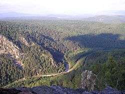 Karatash Ridge, a protected area of Russia in Salavatsky District | |
.png) |
 |
|
| |
| Location | |
| Country | Russia |
| Federal subject | Republic of Bashkortostan[1] |
| Administrative structure (as of February 2013) | |
| Administrative center | selo of Maloyaz[2] |
| Administrative divisions:[3] | |
| Selsoviets | 16 |
| Inhabited localities:[3] | |
| Rural localities | 60 |
| Municipal structure (as of December 2012) | |
| Municipally incorporated as | Salavatsky Municipal District[4] |
| Municipal divisions:[4] | |
| Urban settlements | 0 |
| Rural settlements | 16 |
| Statistics | |
| Area | 2,182 km2 (842 sq mi)[5] |
| Population (2010 Census) | 26,566 inhabitants[6] |
| • Urban | 0% |
| • Rural | 100% |
| Population (January 2015 est.) | 24,632 inhabitants[5] |
| Density | 12.18/km2 (31.5/sq mi)[7] |
| Time zone | YEKT (UTC+05:00)[8] |
| Established | January 31, 1935[5] |
| Previous names | Maloyazovsky District (until March 4, 1941)[5] |
| Official website | |
| Salavatsky District on WikiCommons | |
Salavatsky District (Russian: Салава́тский райо́н; Bashkir: Салауат районы) is an administrative[1] and municipal[4] district (raion), one of the fifty-four in the Republic of Bashkortostan, Russia. It is located in the northeast of the republic and borders Duvansky District in the north, Kiginsky District in the northeast, Chelyabinsk Oblast in the east, south, and west, and Nurimanovsky District in the west. The area of the district is 2,182 square kilometers (842 sq mi).[5] Its administrative center is the rural locality (a selo) of Maloyaz.[2] As of the 2010 Census, the total population of the district was 26,566, with the population of Maloyaz accounting for 18.5% of that number.[6]
History
The district was established on January 31, 1935 as Maloyazovsky District (Малоязовский район).[5] On March 4, 1941, it was given its present name,[5] in honor of Salawat Yulayev, a Bashkir national hero who was born in the village of Tikeyevo and who played a role in Pugachev's Rebellion.
Administrative and municipal status
Within the framework of administrative divisions, Salavatsky District is one of the fifty-four in the Republic of Bashkortostan.[1] The district is divided into sixteen selsoviets, comprising sixty rural localities.[3] As a municipal division, the district is incorporated as Salavatsky Municipal District.[4] Its sixteen selsoviets are incorporated as sixteen rural settlements within the municipal district.[4] The selo of Maloyaz serves as the administrative center of both the administrative[2] and municipal[4] district.
Demographics
| 2010 Census | 26,566[6] |
|---|---|
| 2002 Census | 28,516[9] |
| 1989 Census | 26,897[10] |
| 1979 Census | 28,843[11] |
In terms of ethnic composition, 66% of the population are Bashkirs, 22% are Tatars, and 10% are Russians.[5]
References
Notes
- 1 2 3 Constitution of the Republic of Bashkortostan, Article 64
- 1 2 3 Государственный комитет Российской Федерации по статистике. Комитет Российской Федерации по стандартизации, метрологии и сертификации. №ОК 019-95 1 января 1997 г. «Общероссийский классификатор объектов административно-территориального деления. Код 80 247», в ред. изменения №278/2015 от 1 января 2016 г.. (State Statistics Committee of the Russian Federation. Committee of the Russian Federation on Standardization, Metrology, and Certification. #OK 019-95 January 1, 1997 Russian Classification of Objects of Administrative Division . Code 80 247, as amended by the Amendment #278/2015 of January 1, 2016. ).
- 1 2 3 Resolution #391
- 1 2 3 4 5 6 Law #126-z
- 1 2 3 4 5 6 7 8 {cite web|title=About the District|url=https://admmaloyaz.bashkortostan.ru/about/%7Cwebsite=Salavatsky District|publisher=Salavatsky District|accessdate=November 9, 2017}} (in Russian)
- 1 2 3 Russian Federal State Statistics Service (2011). "Всероссийская перепись населения 2010 года. Том 1" [2010 All-Russian Population Census, vol. 1]. Всероссийская перепись населения 2010 года (2010 All-Russia Population Census) (in Russian). Federal State Statistics Service. Retrieved June 29, 2012.
- ↑ The value of density was calculated automatically by dividing the 2010 Census population by the area specified in the infobox. Please note that this value is only approximate as the area specified in the infobox does not necessarily correspond to the area of the entity proper or is reported for the same year as the population.
- ↑ Правительство Российской Федерации. Федеральный закон №107-ФЗ от 3 июня 2011 г. «Об исчислении времени», в ред. Федерального закона №271-ФЗ от 03 июля 2016 г. «О внесении изменений в Федеральный закон "Об исчислении времени"». Вступил в силу по истечении шестидесяти дней после дня официального опубликования (6 августа 2011 г.). Опубликован: "Российская газета", №120, 6 июня 2011 г. (Government of the Russian Federation. Federal Law #107-FZ of June 31, 2011 On Calculating Time, as amended by the Federal Law #271-FZ of July 03, 2016 On Amending Federal Law "On Calculating Time". Effective as of after sixty days following the day of the official publication.).
- ↑ Russian Federal State Statistics Service (May 21, 2004). "Численность населения России, субъектов Российской Федерации в составе федеральных округов, районов, городских поселений, сельских населённых пунктов – районных центров и сельских населённых пунктов с населением 3 тысячи и более человек" [Population of Russia, Its Federal Districts, Federal Subjects, Districts, Urban Localities, Rural Localities—Administrative Centers, and Rural Localities with Population of Over 3,000] (XLS). Всероссийская перепись населения 2002 года [All-Russia Population Census of 2002] (in Russian). Retrieved August 9, 2014.
- ↑ Demoscope Weekly (1989). "Всесоюзная перепись населения 1989 г. Численность наличного населения союзных и автономных республик, автономных областей и округов, краёв, областей, районов, городских поселений и сёл-райцентров" [All Union Population Census of 1989: Present Population of Union and Autonomous Republics, Autonomous Oblasts and Okrugs, Krais, Oblasts, Districts, Urban Settlements, and Villages Serving as District Administrative Centers]. Всесоюзная перепись населения 1989 года [All-Union Population Census of 1989] (in Russian). Институт демографии Национального исследовательского университета: Высшая школа экономики [Institute of Demography at the National Research University: Higher School of Economics]. Retrieved August 9, 2014.
- ↑ "Всесоюзная перепись населения 1979 г. Национальный состав населения по регионам России. (All Union Population Census of 1979. Ethnic composition of the population by regions of Russia.)". Всесоюзная перепись населения 1979 года (All-Union Population Census of 1979) (in Russian). Demoscope Weekly (website of the Institute of Demographics of the State University—Higher School of Economics. 1979. Retrieved 2008-11-25.
Sources
- №ВС-22/15 24 декабря 1993 г. «Конституция Республики Башкортостан», в ред. Закона №57-з от 4 марта 2014 г. «О внесении изменений и дополнений в Конституцию Республики Башкортостан». Опубликован: "Ведомости Верховного Совета и Правительства Республики Башкортостан", №4-22, ст.146, 1994. (#VS-22/15 December 24, 1993 Constitution of the Republic of Bashkortostan, as amended by the Law #57-z of March 4, 2014 On Amending and Supplementing the Constitution of the Republic of Bashkortostan. ).
- Правительство Республики Башкортостан. Постановление №391 от 29 декабря 2006 г. «Об утверждении реестра административно-территориальных единиц и населённых пунктов Республики Башкортостан», в ред. Постановления №61 от 26 февраля 2013 г. «О внесении изменений в реестр административно-территориальных единиц и населённых пунктов Республики Башкортостан». Опубликован: "Ведомости Государственного Собрания – Курултая, Президента и Правительства Республики Башкортостан", №5 (251), ст. 239, 12 марта 2007 г. (Government of the Republic of Bashkortostan. Resolution #391 of December 29, 2006 On Adoption of the Registry of the Administrative-Territorial Entities and Inhabited Localities of the Republic of Bashkortostan, as amended by the Resolution #61 of February 26, 2013 On Amending the Registry of the Administrative-Territorial Entities and Inhabited Localities of the Republic of Bashkortostan. ).
- Государственное Собрание —Курултай Республики Башкортостан. Закон №162-з от 17 декабря 2004 г. «О границах, статусе и административных центрах муниципальных образований в Республике Башкортостан», в ред. Закона №572-з от 17 июля 2012 г. «О внесении изменения в статью 2 Закона Республики Башкортостан "О границах, статусе и административных центрах муниципальных образований в Республике Башкортостан"». Вступил в силу в соответствии со статьёй 33. Опубликован: "Республика Башкортостан", №52 (25785), 22 марта 2005 г. (State Assembly of Bashkortostan—El Kurultai. Law #162-z of December 17, 2004 On the Borders, Status, and Administrative Centers of the Municipal Formations in the Republic of Bashkortostan, as amended by the Law #572-z of July 17, 2012 On Amending Article 2 of the Law of the Republic of Bashkortostan "On the Borders, Status, and Administrative Centers of the Municipal Formations in the Republic of Bashkortostan". Effective as of the date established in accordance with the provisions of Article 33.).