Sakmara River
Coordinates: 51°46′20″N 55°01′35″E / 51.7722°N 55.0264°E
| Sakmara River, Haqmar River | |
|---|---|
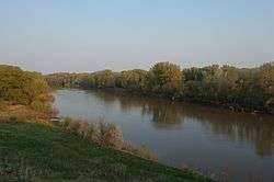 Sakmara River near Saraktash, Russia | |
| Country | Republic of Bashkortostan and Orenburg Oblast, Russia |
| Physical characteristics | |
| Main source | Uraltau range, Urals, Bashkortostan |
| River mouth | Ural River, Orenburg |
| Length | 798 km (496 mi) |
| Discharge |
|
| Basin features | |
| Basin size | 30,200 km2 (11,700 sq mi) |
Sakmara River (Russian: Сакмара; Bashkir: Һаҡмар, Haqmar) is a river in Russia that drains the southern tip of the Ural Mountains south into the Ural River. It is 760 kilometres (470 mi) long. It is a tributary of the Ural River, which it meets in Orenburg. The source of the Sakmara River is in the Republic of Bashkortostan. Other towns along the Sakmara are Yuldybayevo (Bashkortostan), Kuvandyk, and railway station Saraktash clouse to the Wozdwizhenskaya Fortress (Orenburg Oblast).
It rises in the southern Ural Mountains about 60 kilometres (37 mi) west-southwest of Magnitogorsk and flows south through a valley with some canyon development. At Kuvandyk it swings west, leaves the mountains and flows west parallel to the Ural River with many meanders for about 150 kilometres (93 mi) (straight-line distance) before turning south to meet the Ural. Major tributaries are the Salymysh River and the Bolshoy Ik River, both from the north.[1]
The Sakmarian Age of the Permian Period of geological time is named for the Sakmara River.
References