Sakaide, Kagawa
| Sakaide 坂出市 | |||
|---|---|---|---|
| City | |||
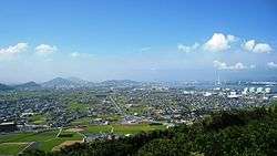 Sakaide City Skyline | |||
| |||
 Location of Sakaide in Kagawa Prefecture | |||
 Sakaide Location in Japan | |||
| Coordinates: 34°19′N 133°52′E / 34.317°N 133.867°ECoordinates: 34°19′N 133°52′E / 34.317°N 133.867°E | |||
| Country | Japan | ||
| Region | Shikoku | ||
| Prefecture | Kagawa Prefecture | ||
| Government | |||
| • Mayor | Toshiaki Matsuura | ||
| Area | |||
| • Total | 92.46 km2 (35.70 sq mi) | ||
| Population (May 1, 2017) | |||
| • Total | 52,281 | ||
| • Density | 570/km2 (1,500/sq mi) | ||
| Symbols | |||
| • Tree | Sangoju (Viburnum odoratissimum var. awabuki) | ||
| • Flower | Sakura and Cosmos | ||
| Time zone | UTC+9 (JST) | ||
| City hall address |
2-3-5, Muromachi, Sakaide-shi, Kagawa-ken 762-8601 | ||
| Website |
www | ||


Sakaide (坂出市 Sakaide-shi) is a city located in Kagawa Prefecture, Japan.
As of May 2017, the city has an estimated population of 52,281 and a population density of 570 persons per km².[1] The total area is 92.46 km².
The city was founded on July 1, 1942. The Great Seto Bridge connects it with Kurashiki, Okayama Prefecture across the Inland Sea.
References
- ↑ "Official website of Sakaide City" (in Japanese). Japan: Sakaide City. Retrieved 9 May 2017.
External links
| Wikimedia Commons has media related to Sakaide, Kagawa. |
- Sakaide City official website (in Japanese)
| Core city | ||
|---|---|---|
| Cities | ||
| Districts | ||
| Authority control |
|---|
This article is issued from
Wikipedia.
The text is licensed under Creative Commons - Attribution - Sharealike.
Additional terms may apply for the media files.