Sainte-Suzanne, Mayenne
| Sainte-Suzanne | ||
|---|---|---|
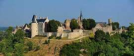 A view of Sainte-Suzanne, from Tertre Ganne | ||
| ||
 Sainte-Suzanne Location within Pays de la Loire region  Sainte-Suzanne | ||
| Coordinates: 48°05′54″N 0°21′06″W / 48.0983°N 0.3516°WCoordinates: 48°05′54″N 0°21′06″W / 48.0983°N 0.3516°W | ||
| Country | France | |
| Region | Pays de la Loire | |
| Department | Mayenne | |
| Arrondissement | Laval | |
| Canton | Meslay-du-Maine | |
| Area1 | 23.14 km2 (8.93 sq mi) | |
| Population (2006)2 | 982 | |
| • Density | 42/km2 (110/sq mi) | |
| Time zone | UTC+1 (CET) | |
| • Summer (DST) | UTC+2 (CEST) | |
| INSEE/Postal code | 53255 /53270 | |
| Elevation |
86–220 m (282–722 ft) (avg. 170 m or 560 ft) | |
|
1 French Land Register data, which excludes lakes, ponds, glaciers > 1 km2 (0.386 sq mi or 247 acres) and river estuaries. 2 Population without double counting: residents of multiple communes (e.g., students and military personnel) only counted once. | ||

Sainte-Suzanne is a former commune in the Mayenne department in north-western France. On 1 January 2016, it was merged into the new commune of Sainte-Suzanne-et-Chammes.[1] French composer Jean Déré died in Sainte-Suzanne on 6 December 1970.
See also
References
- ↑ Arrêté préfectoral 10 October 2015
| Wikimedia Commons has media related to Sainte-Suzanne, Mayenne. |
This article is issued from
Wikipedia.
The text is licensed under Creative Commons - Attribution - Sharealike.
Additional terms may apply for the media files.