Saint Saviour, Jersey
| Saint Saviour Saint Saûveux | ||
|---|---|---|
| Jersey parish | ||
| Saint-Sauveur | ||
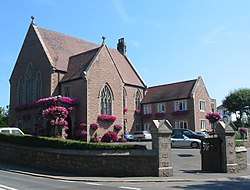 Parish Hall of Saint Saviour | ||
| ||
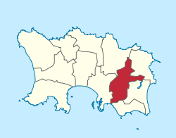 Location of Saint Saviour Saint-Sauveur Saint Saûveux in Jersey | ||
| Crown Dependency | Jersey, Channel Islands | |
| Government[1] | ||
| • Connétable | Sadie Rennard | |
| Area | ||
| • Total | 9.3 km2 (3.6 sq mi) | |
| Area rank | Ranked 8th | |
| Population (2011) | ||
| • Total | 13,580 | |
| • Density | 1,500/km2 (3,800/sq mi) | |
| Time zone | GMT | |
| • Summer (DST) | UTC+01 | |
| Postcode district | JE2 | |
| Postcode sector | 7 | |
.svg.png)
Saint Saviour (Jèrriais: St Saûveux/St Sauveur) is one of the twelve parishes of Jersey in the Channel Islands.
It has a land surface area of 3.6 square miles (9.3 km2), borders with five other parishes, and has a very small coastline at Le Dicq.
Vingtaines

The parish is divided into vingtaines for administrative purposes as follows:
- La Vingtaine de Maufant
- La Vingtaine de Sous la Hougue
- La Vingtaine des Pigneaux
- La Vingtaine de la Grande Longueville
- La Vingtaine de la Petite Longueville
- La Vingtaine de Sous l'Église
For electoral purposes the parish is divided into three districts:
- District No. 1 (Vingtaine de la Petite Longueville) elects two Deputies
- District No. 2 (Vingtaine de Sous l'Église) elects two Deputies
- District No. 3 (Vingtaines de Maufant, de Sous la Hougue, des Pigneaux and de la Grande Longueville) elects one Deputy
Demographics
Saint Saviour is Jersey's second most populated parish, with 13,580 residents in 2011.
| Historical population | ||
|---|---|---|
| Year | Pop. | ±% |
| 1991 | 12,747 | — |
| 1996 | 12,680 | −0.5% |
| 2001 | 12,491 | −1.5% |
| 2011 | 13,580 | +8.7% |
Notable sites
See also
References
- ↑ "BBC News - Sadie Rennard wins Jersey constable vote in St Saviour". Bbc.co.uk. 2011-10-19. Retrieved 2012-10-05.
External links
Coordinates: 49°11′25″N 2°04′45″W / 49.19023°N 2.07916°W
This article is issued from
Wikipedia.
The text is licensed under Creative Commons - Attribution - Sharealike.
Additional terms may apply for the media files.