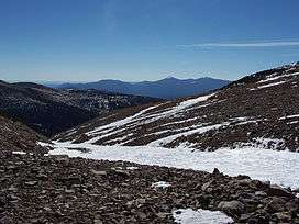
Saint Mary's Glacier
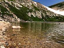
Glacial Lake at the base of Saint Mary's Glacier
| Saint Mary's Glacier | |
|---|---|
 Saint Mary's Glacier | |
 Saint Mary's Glacier Location in Colorado | |
| Type | Mountain glacier |
| Location | Clear Creek County, Colorado, United States |
| Coordinates | 39°50′09″N 105°38′49″W / 39.83583°N 105.64694°WCoordinates: 39°50′09″N 105°38′49″W / 39.83583°N 105.64694°W[1] |
| Terminus | Talus/proglacial lake |
| Status | Retreating |
Saint Mary's Glacier (or Saint Marys) is a semi-permanent snowfield located in Arapaho National Forest in the U.S. state of Colorado.[2] Saint Mary's Glacier is 2.5 mi (4.0 km) southeast of James Peak.[3]
See also
References
- ↑ "Saint Marys Glacier". Geographic Names Information System. United States Geological Survey. Retrieved 2012-08-18.
- ↑ Empire, CO (Map). TopoQwest (United States Geological Survey Maps). Retrieved 2012-08-18.
- ↑ "Glaciers of Colorado". Glaciers of the American West. Portland State University. Retrieved 2012-08-18.
This article is issued from
Wikipedia.
The text is licensed under Creative Commons - Attribution - Sharealike.
Additional terms may apply for the media files.