Saint George Parish, Dominica
| Saint George | |
| Parish | |
 Roseau's French Quarter | |
| Country | Dominica |
|---|---|
| Capital | Roseau |
| - coordinates | 15°18′05″N 61°23′18″W / 15.30139°N 61.38833°WCoordinates: 15°18′05″N 61°23′18″W / 15.30139°N 61.38833°W |
| Area | 56.2 km2 (22 sq mi) |
| Population | 21,141 (2011) |
| Density | 376/km2 (974/sq mi) |
| Timezone | UTC-4 |
| ISO 3166-2 | DM-04 |
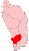 | |
Saint George is one of Dominica's 10 administrative parishes. It is bordered by Saint Paul and part of the Boeri River (to the north), Saint David and Saint Patrick (to the east), Saint Luke (to the south).
The parish has an area of 56.1 km² (21.67 mi²),[1] and has a population of 20,211.[2]
Roseau
The capital city of Dominica, Roseau, is in this parish, as well as its suburbs:
- Bath Estate
- Elmshall
- Kings Hill
- Copthall
- Newtown (once Charlotteville)
- Castle Comfort
- Goodwill
- Potters Ville
- Stock Farm
- Tarish Pit
- Yam Piece
- Belle Vue Rawle
- Fond Colé
.jpg)
Roseau
.jpg)
Rainforest at Trafalgar Falls
Other settlements
(all villages) Louisville
- Fond Cani
- Trafalgar
- Wotten Waven
- Morne Prosper
- Giraudel
- Eggleston
- Laudat
- Loubiere
- Bellevue Chopin
References
This article is issued from
Wikipedia.
The text is licensed under Creative Commons - Attribution - Sharealike.
Additional terms may apply for the media files.