Saint-Pierre-du-Mesnil
| Saint-Pierre-du-Mesnil | |
|---|---|
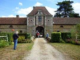 Blanc-Buisson Castle | |
 Saint-Pierre-du-Mesnil Location within Normandy region  Saint-Pierre-du-Mesnil | |
| Coordinates: 48°56′08″N 0°34′41″E / 48.9356°N 0.5781°ECoordinates: 48°56′08″N 0°34′41″E / 48.9356°N 0.5781°E | |
| Country | France |
| Region | Normandy |
| Department | Eure |
| Arrondissement | Bernay |
| Canton | Bernay |
| Government | |
| • Mayor (2008–2014) | Jean-Michel Adeline |
| Area1 | 7.92 km2 (3.06 sq mi) |
| Population (2008)2 | 104 |
| • Density | 13/km2 (34/sq mi) |
| Time zone | UTC+1 (CET) |
| • Summer (DST) | UTC+2 (CEST) |
| INSEE/Postal code | 27596 /27330 |
| Elevation |
195–212 m (640–696 ft) (avg. 208 m or 682 ft) |
|
1 French Land Register data, which excludes lakes, ponds, glaciers > 1 km2 (0.386 sq mi or 247 acres) and river estuaries. 2 Population without double counting: residents of multiple communes (e.g., students and military personnel) only counted once. | |
Saint-Pierre-du-Mesnil is a former commune in the Eure department in Normandy in northern France. On 1 January 2016, it was merged into the new commune of Mesnil-en-Ouche.[1]
Population
| Historical population | ||
|---|---|---|
| Year | Pop. | ±% |
| 1962 | 130 | — |
| 1968 | 152 | +16.9% |
| 1975 | 115 | −24.3% |
| 1982 | 89 | −22.6% |
| 1990 | 90 | +1.1% |
| 1999 | 86 | −4.4% |
| 2008 | 104 | +20.9% |
See also
References
- ↑ Arrêté préfectoral 9 December 2015 (in French)
| Wikimedia Commons has media related to Saint-Pierre-du-Mesnil. |
This article is issued from
Wikipedia.
The text is licensed under Creative Commons - Attribution - Sharealike.
Additional terms may apply for the media files.