Saint-Pellerin, Eure-et-Loir
| Saint-Pellerin | |
|---|---|
 | |
 Saint-Pellerin Location within Centre-Val de Loire region  Saint-Pellerin | |
| Coordinates: 48°04′20″N 1°08′32″E / 48.0722°N 1.1422°ECoordinates: 48°04′20″N 1°08′32″E / 48.0722°N 1.1422°E | |
| Country | France |
| Region | Centre-Val de Loire |
| Department | Eure-et-Loir |
| Arrondissement | Châteaudun |
| Canton | Brou |
| Area1 | 13.68 km2 (5.28 sq mi) |
| Population (2008)2 | 364 |
| • Density | 27/km2 (69/sq mi) |
| Time zone | UTC+1 (CET) |
| • Summer (DST) | UTC+2 (CEST) |
| INSEE/Postal code | 28356 /28290 |
| Elevation |
126–162 m (413–531 ft) (avg. 156 m or 512 ft) |
|
1 French Land Register data, which excludes lakes, ponds, glaciers > 1 km2 (0.386 sq mi or 247 acres) and river estuaries. 2 Population without double counting: residents of multiple communes (e.g., students and military personnel) only counted once. | |
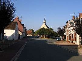
Saint-Pellerin is a former commune in the Eure-et-Loir department in northern France. On 1 January 2017, it was merged into the new commune Commune nouvelle d'Arrou.[1]
Population
| Historical population | ||
|---|---|---|
| Year | Pop. | ±% |
| 1962 | 282 | — |
| 1968 | 368 | +30.5% |
| 1975 | 320 | −13.0% |
| 1982 | 305 | −4.7% |
| 1990 | 316 | +3.6% |
| 1999 | 319 | +0.9% |
| 2008 | 364 | +14.1% |
See also
References
- ↑ Arrêté préfectoral 25 May 2016 (in French)
| Wikimedia Commons has media related to Saint-Pellerin (Eure-et-Loir). |
This article is issued from
Wikipedia.
The text is licensed under Creative Commons - Attribution - Sharealike.
Additional terms may apply for the media files.