Saint-Maurice-de-Ventalon
| Saint-Maurice-de-Ventalon | ||
|---|---|---|
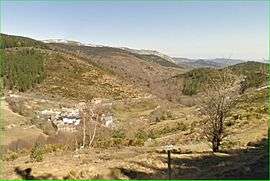 The village, in the valley of Luech | ||
| ||
 Saint-Maurice-de-Ventalon Location within Occitanie region  Saint-Maurice-de-Ventalon | ||
| Coordinates: 44°19′25″N 3°49′47″E / 44.3236°N 3.8297°ECoordinates: 44°19′25″N 3°49′47″E / 44.3236°N 3.8297°E | ||
| Country | France | |
| Region | Occitanie | |
| Department | Lozère | |
| Arrondissement | Florac | |
| Canton | Saint-Étienne-du-Valdonnez | |
| Intercommunality | Cévennes au Mont Lozère | |
| Government | ||
| • Mayor (2008–2014) | Jean-Paul Velay | |
| Area1 | 38.51 km2 (14.87 sq mi) | |
| Population (1999)2 | 80 | |
| • Density | 2.1/km2 (5.4/sq mi) | |
| Time zone | UTC+1 (CET) | |
| • Summer (DST) | UTC+2 (CEST) | |
| INSEE/Postal code | 48172 /48220 | |
| Elevation |
640–1,493 m (2,100–4,898 ft) (avg. 1,000 m or 3,300 ft) | |
|
1 French Land Register data, which excludes lakes, ponds, glaciers > 1 km2 (0.386 sq mi or 247 acres) and river estuaries. 2 Population without double counting: residents of multiple communes (e.g., students and military personnel) only counted once. | ||

Saint-Maurice-de-Ventalon is a former commune in the Lozère department in southern France. On 1 January 2016, it was merged into the new commune of Pont-de-Montvert-Sud-Mont-Lozère.[1]
See also
References
- ↑ Arrêté préfectoral 8 December 2015
| Wikimedia Commons has media related to Saint-Maurice-de-Ventalon. |
This article is issued from
Wikipedia.
The text is licensed under Creative Commons - Attribution - Sharealike.
Additional terms may apply for the media files.