Saint-Mars-la-Jaille
| Saint-Mars-la-Jaille | ||
|---|---|---|
| Commune | ||
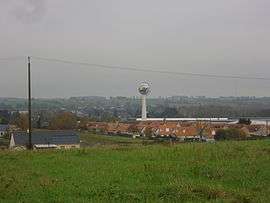 A general view of Saint-Mars-la-Jaille | ||
| ||
 Saint-Mars-la-Jaille Location within Pays de la Loire region  Saint-Mars-la-Jaille | ||
| Coordinates: 47°31′34″N 1°11′01″W / 47.5261°N 1.1836°WCoordinates: 47°31′34″N 1°11′01″W / 47.5261°N 1.1836°W | ||
| Country | France | |
| Region | Pays de la Loire | |
| Department | Loire-Atlantique | |
| Arrondissement | Châteaubriant-Ancenis | |
| Canton | Ancenis | |
| Intercommunality | Pays d'Ancenis | |
| Government | ||
| • Mayor (2008–2014) | Yves Ripoche | |
| Area1 | 20.06 km2 (7.75 sq mi) | |
| Population (1999)2 | 2,192 | |
| • Density | 110/km2 (280/sq mi) | |
| Time zone | UTC+1 (CET) | |
| • Summer (DST) | UTC+2 (CEST) | |
| INSEE/Postal code | 44180 /44540 | |
| Elevation |
22–88 m (72–289 ft) (avg. 30 m or 98 ft) | |
|
1 French Land Register data, which excludes lakes, ponds, glaciers > 1 km2 (0.386 sq mi or 247 acres) and river estuaries. 2 Population without double counting: residents of multiple communes (e.g., students and military personnel) only counted once. | ||
.svg.png)
Saint-Mars-la-Jaille is a former commune in the Loire-Atlantique department in western France. On 1 January 2018, it was merged into the new commune of Vallons-de-l'Erdre.[1]
See also
References
- ↑ Arrêté préfectoral 29 December 2017 (in French)
| Wikimedia Commons has media related to Saint-Mars-la-Jaille. |
This article is issued from
Wikipedia.
The text is licensed under Creative Commons - Attribution - Sharealike.
Additional terms may apply for the media files.