Saint-Laurent-d'Oingt
| Saint-Laurent-d'Oingt | |
|---|---|
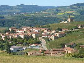 A general view of Saint-Laurent-d'Oingt | |
 Saint-Laurent-d'Oingt Location within Auvergne-Rhône-Alpes region  Saint-Laurent-d'Oingt | |
| Coordinates: 45°56′42″N 4°33′50″E / 45.945°N 4.5639°ECoordinates: 45°56′42″N 4°33′50″E / 45.945°N 4.5639°E | |
| Country | France |
| Region | Auvergne-Rhône-Alpes |
| Department | Rhône |
| Arrondissement | Villefranche-sur-Saône |
| Canton | Le Bois-d'Oingt |
| Area1 | 9.05 km2 (3.49 sq mi) |
| Population (2014)2 | 834 |
| • Density | 92/km2 (240/sq mi) |
| Time zone | UTC+1 (CET) |
| • Summer (DST) | UTC+2 (CEST) |
| INSEE/Postal code | 69222 /69620 |
| Elevation |
252–548 m (827–1,798 ft) (avg. 440 m or 1,440 ft) |
|
1 French Land Register data, which excludes lakes, ponds, glaciers > 1 km2 (0.386 sq mi or 247 acres) and river estuaries. 2 Population without double counting: residents of multiple communes (e.g., students and military personnel) only counted once. | |
Saint-Laurent-d'Oingt is a former commune in the Rhône department of the Auvergne-Rhône-Alpes region in eastern France. On 1 January 2017, Le Bois-d'Oingt, Oingt and Saint-Laurent-d'Oingt merged becoming one commune of Val d'Oingt. [1]
See also
References
- ↑ (in French) Arrêté du 22 septembre 2016 portant création de la commune nouvelle de Val d'Oingt], Journal officiel.
| Wikimedia Commons has media related to Saint-Laurent-d'Oingt. |
This article is issued from
Wikipedia.
The text is licensed under Creative Commons - Attribution - Sharealike.
Additional terms may apply for the media files.