Saint-Julien-près-Bort
| Saint-Julien-près-Bort | ||
|---|---|---|
 The Dordogne | ||
| ||
 Saint-Julien-près-Bort Location within Nouvelle-Aquitaine region  Saint-Julien-près-Bort | ||
| Coordinates: 45°24′59″N 2°24′15″E / 45.4164°N 2.4042°ECoordinates: 45°24′59″N 2°24′15″E / 45.4164°N 2.4042°E | ||
| Country | France | |
| Region | Nouvelle-Aquitaine | |
| Department | Corrèze | |
| Arrondissement | Ussel | |
| Canton | Haute-Dordogne | |
| Area1 | 30.63 km2 (11.83 sq mi) | |
| Population (2008)2 | 422 | |
| • Density | 14/km2 (36/sq mi) | |
| Time zone | UTC+1 (CET) | |
| • Summer (DST) | UTC+2 (CEST) | |
| INSEE/Postal code | 19218 /19110 | |
| Elevation | 400–841 m (1,312–2,759 ft) | |
|
1 French Land Register data, which excludes lakes, ponds, glaciers > 1 km2 (0.386 sq mi or 247 acres) and river estuaries. 2 Population without double counting: residents of multiple communes (e.g., students and military personnel) only counted once. | ||
.svg.png)
Saint-Julien-près-Bort is a former commune in the Corrèze department in central France. On 1 January 2017, it was merged into the new commune Sarroux-Saint Julien.[1]
Geography
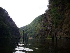
The river Diège forms all of the commune's western boundary, then flows into the Dordogne, which forms all of its southern boundary.
Population
| Historical population | ||
|---|---|---|
| Year | Pop. | ±% |
| 1962 | 543 | — |
| 1968 | 459 | −15.5% |
| 1975 | 367 | −20.0% |
| 1982 | 350 | −4.6% |
| 1990 | 373 | +6.6% |
| 1999 | 369 | −1.1% |
| 2008 | 422 | +14.4% |
See also
References
- ↑ Arrêté préfectoral 22 June 2016 (in French)
| Wikimedia Commons has media related to Saint-Julien-près-Bort. |
This article is issued from
Wikipedia.
The text is licensed under Creative Commons - Attribution - Sharealike.
Additional terms may apply for the media files.