Saint-Julien-du-Tournel
| Saint-Julien-du-Tournel | |
|---|---|
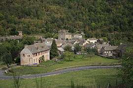 A general view of Saint-Julien-du-Tournel | |
 Saint-Julien-du-Tournel Location within Occitanie region  Saint-Julien-du-Tournel | |
| Coordinates: 44°30′06″N 3°41′05″E / 44.5017°N 3.6847°ECoordinates: 44°30′06″N 3°41′05″E / 44.5017°N 3.6847°E | |
| Country | France |
| Region | Occitanie |
| Department | Lozère |
| Arrondissement | Mende |
| Canton | Saint-Étienne-du-Valdonnez |
| Area1 | 38.57 km2 (14.89 sq mi) |
| Population (1999)2 | 109 |
| • Density | 2.8/km2 (7.3/sq mi) |
| Time zone | UTC+1 (CET) |
| • Summer (DST) | UTC+2 (CEST) |
| INSEE/Postal code | 48164 /48190 |
| Elevation |
912–1,542 m (2,992–5,059 ft) (avg. 964 m or 3,163 ft) |
|
1 French Land Register data, which excludes lakes, ponds, glaciers > 1 km2 (0.386 sq mi or 247 acres) and river estuaries. 2 Population without double counting: residents of multiple communes (e.g., students and military personnel) only counted once. | |
Saint-Julien-du-Tournel is a former commune in the Lozère department in southern France. On 1 January 2017, it was merged into the new commune Mont Lozère et Goulet.[1]
See also
References
- ↑ Arrêté préfectoral 23 May 2016 (in French)
| Wikimedia Commons has media related to Saint-Julien-du-Tournel. |
This article is issued from
Wikipedia.
The text is licensed under Creative Commons - Attribution - Sharealike.
Additional terms may apply for the media files.