Saint-Camille, Quebec
| Saint-Camille | |
|---|---|
| Township municipality | |
 | |
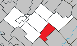 Location within Les Sources RCM. | |
 Saint-Camille Location in southern Quebec. | |
| Coordinates: 45°41′N 71°42′W / 45.683°N 71.700°WCoordinates: 45°41′N 71°42′W / 45.683°N 71.700°W[1] | |
| Country |
|
| Province |
|
| Region | Estrie |
| RCM | Les Sources |
| Constituted | January 1, 1860 |
| Named for | Camillus de Lellis[1] |
| Government[2] | |
| • Mayor | Benoit Bourassa |
| • Federal riding | Richmond—Arthabaska |
| • Prov. riding | Richmond |
| Area[2][3] | |
| • Total | 83.60 km2 (32.28 sq mi) |
| • Land | 82.66 km2 (31.92 sq mi) |
| Population (2011)[3] | |
| • Total | 511 |
| • Density | 6.2/km2 (16/sq mi) |
| • Pop 2006-2011 |
|
| Time zone | UTC−5 (EST) |
| • Summer (DST) | UTC−4 (EDT) |
| Postal code(s) | J0A 1G0 |
| Area code(s) | 819 |
| Highways |
|
| Website |
www |
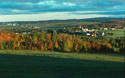
Saint-Camille is a township municipality in the Canadian province of Quebec, located within the Les Sources Regional County Municipality. The township had a population of 511 in the Canada 2011 Census.
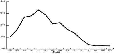
Population of Saint-Camille 1871-2001
References
External links

Places adjacent to Saint-Camille, Quebec | ||||||||||
|---|---|---|---|---|---|---|---|---|---|---|
| ||||||||||
| Cities | |
|---|---|
| Municipalities | |
| Townships | |
| |
This article is issued from
Wikipedia.
The text is licensed under Creative Commons - Attribution - Sharealike.
Additional terms may apply for the media files.