Saint-Bon-Tarentaise
| Saint-Bon-Tarentaise | |
|---|---|
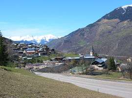 A general view of Saint-Bon | |
 Saint-Bon-Tarentaise Location within Auvergne-Rhône-Alpes region  Saint-Bon-Tarentaise | |
| Coordinates: 45°26′05″N 6°38′16″E / 45.4347°N 6.6378°ECoordinates: 45°26′05″N 6°38′16″E / 45.4347°N 6.6378°E | |
| Country | France |
| Region | Auvergne-Rhône-Alpes |
| Department | Savoie |
| Arrondissement | Albertville |
| Canton | Moûtiers |
| Area1 | 58.94 km2 (22.76 sq mi) |
| Population (2014)2 | 1,910 |
| • Density | 32/km2 (84/sq mi) |
| Time zone | UTC+1 (CET) |
| • Summer (DST) | UTC+2 (CEST) |
| INSEE/Postal code | 73227 /73120 |
| Elevation | 700–3,054 m (2,297–10,020 ft) |
|
1 French Land Register data, which excludes lakes, ponds, glaciers > 1 km2 (0.386 sq mi or 247 acres) and river estuaries. 2 Population without double counting: residents of multiple communes (e.g., students and military personnel) only counted once. | |
Saint-Bon-Tarentaise is a former commune in the Savoie department in the Auvergne-Rhône-Alpes region in south-eastern France. On 1 January 2017, it was merged into the new commune Courchevel.[1]
As well as Saint-Bon-Tarentaise itself, the commune also included the four villages (Le Praz-Courchevel 1300, Courchevel 1550, Moriond-Courchevel 1650 and Courchevel 1850) that together make up the ski resort of Courchevel.
See also
References
- ↑ Arrêté préfectoral 8 August 2016 (in French)
| Wikimedia Commons has media related to Saint-Bon-Tarentaise. |
This article is issued from
Wikipedia.
The text is licensed under Creative Commons - Attribution - Sharealike.
Additional terms may apply for the media files.