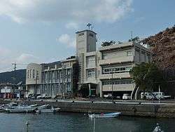
Saiki, Ōita
| Saiki 佐伯市 | |||
|---|---|---|---|
| City | |||
 Saiki City | |||
| |||
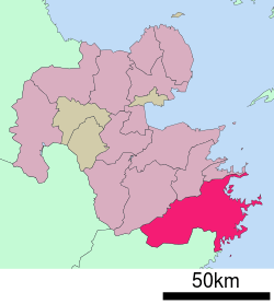 Location of Saiki in Ōita Prefecture | |||
 Saiki Location in Japan | |||
| Coordinates: 32°58′N 131°54′E / 32.967°N 131.900°ECoordinates: 32°58′N 131°54′E / 32.967°N 131.900°E | |||
| Country | Japan | ||
| Region | Kyushu | ||
| Prefecture | Ōita Prefecture | ||
| Government | |||
| • Mayor | Yasuyoshi Nishijima | ||
| Area | |||
| • Total | 903.44 km2 (348.82 sq mi) | ||
| Population (March 31, 2017) | |||
| • Total | 73,546 | ||
| • Density | 81/km2 (210/sq mi) | ||
| Symbols | |||
| • Tree | Oak | ||
| • Flower | Yamazakura (Prunus jamasakura) | ||
| • Bird | Japanese white-eye | ||
| • Fish |
Sea: Aji River: Ayu | ||
| Time zone | UTC+9 (JST) | ||
| City hall address |
1-1, Nakamura Minamimachi, Saiki-shi, Ōita-ken 876-8585 | ||
| Website |
www | ||


Saiki (佐伯市 Saiki-shi) is a city located in Ōita Prefecture, Japan. The city was founded on April 29, 1941.
On March 3, 2005, Saki merged with the towns of Kamae, Kamiura, Tsurumi, Ume and Yayoi, and the villages Honjō, Naokawa and Yonōzu (all from Minamiamabe District) to create the new and expanded Saiki City. Minamiamabe District was dissolved as a result of this merger.
As of March 2017, the new city has an estimated population of 73,546 (former city, 2003: 49,183) and a population density of 81 persons per km2.[1] The total area is 903.44 km2, making it the largest city by area in Kyushu.
Sister city
In the sister city program, Saiki is twinned with the Australian port city Gladstone, Queensland, as well as a sister city with Handan, China.[2]
References
- ↑ "Official website of Saiki city" (in Japanese). Japan: Saiki City. Retrieved 19 April 2017.
- ↑ http://www.hd.gov.cn/
External links

- Saiki City official website (in Japanese)
| Core city | ||
|---|---|---|
| Cities | ||
| Districts | ||
This article is issued from
Wikipedia.
The text is licensed under Creative Commons - Attribution - Sharealike.
Additional terms may apply for the media files.