Saigon railway station
Saigon railway station | |
|---|---|
 | |
| Location |
1 Nguyen Thong Street, Ward 9 District 3 |
| Operated by | Vietnam Railways |
| Line(s) | North-South Railway |
| History | |
| Opened | 1885 |
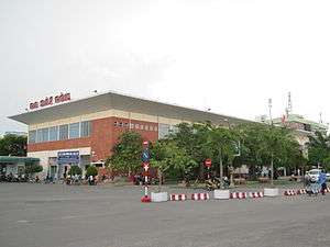
Saigon railway station is a railway station in District 3, Ho Chi Minh City, Vietnam. This station is the largest and most important railway hub in the country due to Ho Chi Minh City being the largest city and the economic centre of Vietnam. Locating about 1 km from the city center, Saigon railway station is the last station on the North-South railway, the last point of the railway in Vietnam
History
The original station, which opened in 1885, was located across from Bến Thành Market in District 1.[1] The current station, originally a baggage holding and shipping centre, was constructed in the early 1930s by the French colonists, as part of the Hanoi-Saigon Railway. The station is situated around 1 km from the downtown city centre.
Every year, 1–2 months before Tết, thousands of people queue all day to buy tickets home as this is the main booking office of Vietnam Railways. Though electronic booking machines have been adopted, these queues continue, due to the monopoly of the railway.
The head - office is in 136 Ham Nghi Street, Ben Thanh ward, district 1, Ho Chi Minh city.
Despite the city being named Ho Chi Minh City after the war, the name of the station has remained the same.
Binh Trieu station
Due to the requirements of urban planning, the city government is considering the relocation of this station to the city outskirt in Binh Trieu (Binh Trieu Railway Station).[2][3]
References
- ↑ "The Changing Faces of Saigon Railway Station, 1885–1983". 14 March 2016.
- ↑ "The Changing Faces of Saigon Railway Station – Future". 14 March 2016.
- ↑ "The Binh Trieu station". International railway journal. 42: 32. 2002.
An 11km elevated line would run from Hoa Hung to Binh Trieu. This would parallel the existing railway and would be the first stage of a double- track elevated express line to Bien Hoa, a further 29km northeast of the city centre.
External links

- Saigon Railways Official Website
- Ticket prices and review of travelling by train from Saigon (HCMC) to Phan Thiet
 |  | ||
| |||
Coordinates: 10°46′56″N 106°40′37″E / 10.7822°N 106.677°E