Saglek Airport
| Saglek Airport | |||||||||||
|---|---|---|---|---|---|---|---|---|---|---|---|
 | |||||||||||
| Summary | |||||||||||
| Airport type |
| ||||||||||
| Operator |
| ||||||||||
| Serves | CFS Saglek | ||||||||||
| Location | Saglek Bay, Labrador | ||||||||||
| Time zone | AST (UTC−04:00) | ||||||||||
| • Summer (DST) | ADT (UTC−03:00) | ||||||||||
| Elevation AMSL | 269 ft / 82 m | ||||||||||
| Coordinates | 58°28′28″N 062°39′15″W / 58.47444°N 62.65417°WCoordinates: 58°28′28″N 062°39′15″W / 58.47444°N 62.65417°W | ||||||||||
| Map | |||||||||||
 CYSV Location in Newfoundland and Labrador | |||||||||||
| Runways | |||||||||||
| |||||||||||
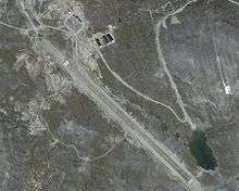
Saglek Airport (IATA: YSV, ICAO: CYSV) is located in the Torngat Mountains in northern Labrador and was originally built by the United States Air Force (USAF) in 1954, as part of the Pinetree Line and formed part of RCAF Station Saglek.
In 1986, the Department of National Defense built an automated, long range radar site that forms part of the current North Warning System.
In addition to providing access to the automated radar site, this airstrip now serves as an access point for a research station located in the Torngat Mountains.
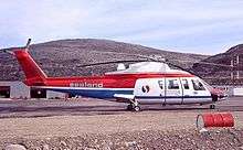
Sealand Helicopters S-76A at CFS Saglek
See also
References
External links
| By name | |
|---|---|
| By location indicator | |
| By province/territory | |
| By area | |
| National Airports System | |
| Related | |
| |
This article is issued from
Wikipedia.
The text is licensed under Creative Commons - Attribution - Sharealike.
Additional terms may apply for the media files.