Sabaragamuwa Province
| Sabaragamuwa Province සබරගමුව පළාත சப்ரகமுவ மாகாணம் | ||
|---|---|---|
| Province | ||
| ||
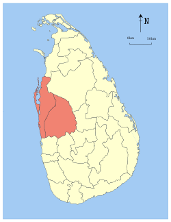
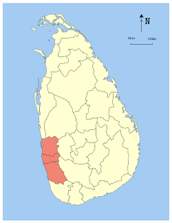
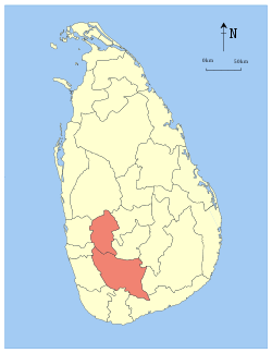 Location within Sri Lanka | ||
| Coordinates: 6°40′N 80°24′E / 6.667°N 80.400°ECoordinates: 6°40′N 80°24′E / 6.667°N 80.400°E | ||
| Country | Sri Lanka | |
| Created | 1889 | |
| Admitted | 14 November 1987 | |
| Capital | Ratnapura | |
| Largest city | Ratnapura | |
| Government | ||
| • Governor | Niluka Ekanayake | |
| • Chief Minister | Maheepala Herath | |
| Area | ||
| • Total | 4,968 km2 (1,918 sq mi) | |
| Area rank | 8th (7.46% of total area) | |
| Population (2011 census) | ||
| • Total | 1,918,880 | |
| • Rank | 5th (9.63% of total pop.) | |
| • Density | 390/km2 (1,000/sq mi) | |
| Gross Regional Product (2010)[1] | ||
| • Total | Rs 303 billion | |
| • Rank | 5th (6.3% of total) | |
| Time zone | UTC+05:30 (Sri Lanka) | |
| ISO 3166 code | LK-9 | |
| Vehicle registration | SG | |
| Official Languages | Sinhalese, Tamil | |
| Website |
www | |
.PNG)
 |
| Sabaragamuwa Province, Sri Lanka |
The Sabaragamuwa Province, (Sinhalese: සබරගමුව පළාත Sabaragamuwa Palata, Tamil: சபரகமுவ மாகாணம் Sabaragamuwa Maakaanam) is one of the nine provinces of Sri Lanka, the first level administrative division of the country. The provinces have existed since the 19th century but did not have any legal status until 1987 when the 13th Amendment to the Constitution of Sri Lanka established provincial councils.[2][3] The Sabaragamuwa Province contains two districts: Ratnapura and Kegalle. It is named after its former indigenous inhabitants, namely the Sabara, an indic term for hunter-gatherer tribes, a term seldom used in ancient Sri Lanka. Sabaragamuwa University is in Belihuloya.
Districts
Sabaragamuwa is divided into 2 districts:
- Kegalle District 1,693 km2 (654 sq mi)
- Ratnapura District 3,275 km2 (1,264 sq mi)
Municipal Council
Urban Council
Other Towns
- Belihuloya
- Eheliyagoda
- Kalawana
- Pelmadulla
- Nivitigala
- Kuruwita
- Mawanella
- Yatiyantota
- Aranayake
- Kahawatte
- Rakwana
- Imbulpe
- Deraniyagala
- Ruwanwella
- Warakapola
- Ayagama
- Ambepussa
- Galigomuwa
- Rambukkana
- Bulathkohupitiya
- Karawanella
- Kitulgala
- Godakawela
- Kolonne
- Opanayaka
- Panamure
- Kiriella
See also
References
- ↑ :.News Line : North, East record highest GDP growth rate Archived 2012-06-20 at the Wayback Machine.
- ↑ "Provinces of Sri Lanka". Statoids.
- ↑ "Provincial Councils". Government of Sri Lanka. Archived from the original on 2009-07-07.
External links
Places adjacent to Sabaragamuwa Province | |
|---|---|
This article is issued from
Wikipedia.
The text is licensed under Creative Commons - Attribution - Sharealike.
Additional terms may apply for the media files.