Sabanas de San Ángel
| Sabanas de San Ángel | |||
|---|---|---|---|
| town | |||
| |||
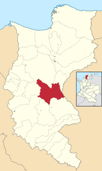 Location of the municipality and town of Sabanas de San Angel in the Department of Magdalena. | |||
| Country | Colombia | ||
| Region | Caribbean | ||
| Department | Magdalena | ||
| Foundation | circa 1607 | ||
| Population (2005) | |||
| • Total | 11,425 | ||
| [1] | |||
| Time zone | UTC-5 | ||
| Website |
www.sabanasdesanangel-magdalena.gov.co | ||
.svg.png)
Sabanas de San Ángel (Spanish pronunciation: [saˈβanas ðe san ˈaŋxel]), Spanish for Savannas of Saint Angel, is a town and municipality of the Colombian Department of Magdalena. Founded around 1607 with the name San Antoñito by the Spanish Colonizers as a pathway town in the route between La Guajira Department and the Magdalena River. On June 24, 1999 the municipality is created with the name of Sabanas de San Angel that segregated from the municipalities of Ariguaní, Pivijay, Chibolo and Plato.
Politics
Administrative divisions
Corregimientos and caseríos:
- Monterrubio
- Casa de Tabla
- La Horqueta
- Flores de Maria
- Pueblo de los Barrios
- San Roque
- Céspedes
- Pueblo Nuevo
- Estación Villa.
References
External links
- (in Spanish) Sabanas de San Angel official website
- (in Spanish) Gobernacion del Magdalena - municipios: Sabanas de San Angel
Coordinates: 10°02′00″N 74°13′00″W / 10.0333°N 74.2167°W
This article is issued from
Wikipedia.
The text is licensed under Creative Commons - Attribution - Sharealike.
Additional terms may apply for the media files.