SSMIS
The Special Sensor Microwave Imager / Sounder (SSMIS) is a 24-channel, 21-frequency, linearly polarized passive microwave radiometer system. The instrument is flown on board the United States Air Force Defense Meteorological Satellite Program (DMSP) F-16, F-17, F-18 and F-19 satellites, which became operational in November 2005, March 2008 March 2016 and May 2016, respectively.[1] It is the successor to the Special Sensor Microwave/Imager (SSM/I). The SSMIS on the F17 satellite stopped producing useful data in April 2016.[2]
Instrument characteristics
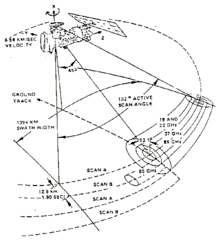
The SSMIS sensor is a passive conically scanning microwave radiometer that combines and extends the current imaging and sounding capabilities of three previously separate DMSP microwave sensors: the SSM/T-1 temperature sounder, the SSMI/T- 2 moisture sounder, and the SSM/I. The SSMIS instrument measures microwave energy at 24 discrete frequencies from 19 to 183 GHz with a swath width of 1700 km.[3] The first SSMIS was launched aboard the DMSP-16 satellite on 18 October 2003. Due to a manufacturing mistake, the polarization for the channels at 50.3, 52.8, 53.6, 54.4 and 55.5 of the first unit of SSMIS (the one flying on DMSP-16) was reversed. Those five channels detect the vertical polarization rather than the Horizontal polarization detected by the successive units of SSMIS.[4]
Table 1: Radiometric characteristics of the SSMIS .[5]
| Frequency (GHz) |
Polarization |
Along track resolution (km) |
Cross-track resolution (km) |
Spatial Sampling (kmxkm) |
Instrument Noise (K) |
| 19.35 | horizontal | 73 | 47 | 45x74 | 0.35 |
| 19.35 | vertical | 73 | 47 | 45x74 | 0.35 |
| 22.235 | vertical | 73 | 47 | 45x74 | 0.45 |
| 37.0 | horizontal | 41 | 31 | 28x45 | 0.22 |
| 37.0 | vertical | 41 | 31 | 28x45 | 0.22 |
| 50.3 | horizontal | 17.6 | 27.3 | 37.5 | 0.34 |
| 52.8 | horizontal | 17.6 | 27.3 | 37.5 | 0.32 |
| 53.596 | horizontal | 17.6 | 27.3 | 37.5 | 0.33 |
| 54.4 | horizontal | 17.6 | 27.3 | 37.5 | 0.33 |
| 55.5 | horizontal | 17.6 | 27.3 | 37.5 | 0.34 |
| 57.29 | right circular | 17.6 | 27.3 | 37.5 | 0.41 |
| 59.4 | right circular | 17.6 | 27.3 | 37.5 | 0.40 |
| 63.283248 ± 0.285271 | right circular | 17.6 | 27.3 | 75 | 2.7 |
| 60.792668 ± 0.357892 | right circular | 17.6 | 27.3 | 75 | 2.7 |
| 60.792668 ± 0.357892 ± 0.002 | right circular | 17.6 | 27.3 | 75 | 1.9 |
| 60.792668 ± 0.357892 ± 0.0055 | right circular | 17.6 | 27.3 | 75 | 1.3 |
| 60.792668 ± 0.357892 ± 0.016 | right circular | 17.6 | 27.3 | 75 | 0.8 |
| 60.792668 ± 0.357892 ± 0.050 | right circular | 17.6 | 27.3 | 75 | 0.9 |
| 91.665 | horizontal | 14 | 13 | 13x16 | 0.19 |
| 91.665 | vertical | 14 | 13 | 13x16 | 0.19 |
| 150 | horizontal | 14 | 13 | 13x16 | 0.53 |
| 183.311 ± 1 | horizontal | 14 | 13 | 13x16 | 0.38 |
| 183.311 ± 3 | horizontal | 14 | 13 | 13x16 | 0.39 |
| 183.311 ± 6.6 | horizontal | 14 | 13 | 13x16 | 0.56 |
References
- ↑ "Special Sensor Microwave/Imager (SSM/I) and Special Sensor Microwave Imager Sounder (SSMIS) Global Gridded Products". National Environmental Satellite, Data, and Information Service (NESDIS), NOAA. Retrieved 24 December 2010.
- ↑ https://www.space.com/32296-air-force-dmsp-19-weather-satellite-dead.html. Missing or empty
|title=(help) - ↑ "SSMI and SSMIS Monitoring and Documentation". National Environmental Satellite, Data, and Information Service (NESDIS), NOAA. Retrieved 24 December 2010.
- ↑ ["Intercalibration between special Sensor Microwave Imager/Sounder and Special Sensor microwave Imager"; B. Yan and F. Weng; IEEE TGRS, 2008, 46, 984]
- ↑ [Special Sensor Microwave Imager and Sounder (SSMIS) Antenna Brightness Temperature Data Record (TDR) Calibration and Validation User Manual"; NOAA/NESDIS; March, 2007 http://www.ncdc.noaa.gov/oa/rsad/ssmi/swath/star-ssmis-tdr-calval-user-manual.pdf (retrieved october 2011)]