Florida State Road 500
| ||||
|---|---|---|---|---|
| Route information | ||||
| Maintained by FDOT | ||||
| Length | 197.949 mi[1] (318.568 km) | |||
| Existed | 1945 – present | |||
| Major junctions | ||||
| South end |
| |||
|
| ||||
| North end |
| |||
| Highway system | ||||
| ||||

State Road 500 (SR 500) is a major state highway running through Florida as a mostly unsigned route under several U.S. Highways. From Chiefland to Williston it is U.S. Highway 27 Alternate. From Williston to Ocala, it is U.S. Highway 27. From Ocala to Kissimmee, it is U.S. Highway 441. From Kissimmee to Indialantic it is U.S. Highway 192.
Names for State Road 500 include Young Boulevard, 100th Street, Hathaway Avenue, Noble Avenue, Blichton Road, 10th Street, Pine Street, Abshier Boulevard, North Boulevard, Main Street, Burleigh Boulevard, Orange Blossom Trail, East Irlo Bronson Memorial Highway, Space Coast Parkway, New Haven Avenue the Melbourne Causeway and Fifth Avenue.
Major intersections
| County | Location | mi[1] | km | Destinations | Notes | ||
|---|---|---|---|---|---|---|---|
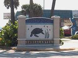
| Brevard | Indialantic | 0.000 | 0.000 | ||||
| see US 192 (mile 74.746-18.123), US 441 (mile 229.899-320.451), US 27 (mile 295.480-319.602) | |||||||
| Levy | Williston | 171.297 | 275.676 | north end of US 27 overlap; south end of US 27 Alt. / US 41 / SR 45 / SR 121 overlap | |||
| see US 27 Alt. (mile 0.000-26.652) | |||||||
| Chiefland | 197.949 | 318.568 | |||||
1.000 mi = 1.609 km; 1.000 km = 0.621 mi
| |||||||
Related route
| |
|---|---|
| Location | Tavares |
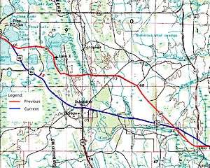
State Road 500A (SR 500A) is a short signed state highway in Tavares, in the U.S. state of Florida, connecting US 441 (SR 500) with SR 19.[2][3] Other alignments have existed, including Lake County's CR Old 441, CR 500A in Orange County, between SR 19 and US 441 through Tavares, Eustis and Mount Dora; and a former section of US 192 in eastern Osceola County.[4] Old USGS maps show the abandoned section of the Kissimmee Highway between Lake X and Deer Park having been SR 500A at some point.
References
- 1 2 FDOT straight line diagrams Archived March 6, 2014, at the Wayback Machine., accessed March 2014
- ↑ "FDOT GIS data".
- ↑ The "FDOT Pavement Management Office Report - Lake County" (PDF). (51.7 KB) shows the road (11240001) as a segment of SR 500. The GIS data however labels it SR 500A.
- ↑ "FDOT Map of Osceola County" (PDF).
External links
| Wikisource has original text related to this article: |