Nevada State Route 160
| ||||
|---|---|---|---|---|
|
Blue Diamond Road Pahrump Valley Road | ||||
 State Route 160, highlighted in red | ||||
| Route information | ||||
| Maintained by NDOT | ||||
| Length | 80.326 mi[1] (129.272 km) | |||
| Existed | 1976 – present | |||
| Major junctions | ||||
| Southeast end | Las Vegas Boulevard south of Las Vegas | |||
|
| ||||
| Northwest end |
| |||
| Location | ||||
| Counties | Clark, Nye | |||
| Highway system | ||||
| ||||

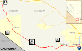
State Route 160 is a state highway in southern Nevada, United States. It connects the southern Las Vegas Valley to U.S. Route 95 northwest of the city via the Pahrump Valley. The southern part of the route sees heavy traffic, mostly due to Pahrump's continued growth as a Las Vegas bedroom community.
The route is known as Blue Diamond Road within the Las Vegas area, with the remainder referred to as the Pahrump Valley Highway.
The route was originally part of State Route 16 and State Route 94 prior to 1978.
Route description
_in_Nye_County%2C_Nevada.jpg)
State Route 160 begins in the southern Las Vegas metro area at the intersection of Las Vegas Boulevard (former SR 604) and East Windmill Lane. It runs west-southwest towards the Red Rock Canyon National Conservation Area and over Mountain Springs Summit (elevation 5,502 feet (1,677 m)) before turning northwest towards Pahrump. Outside of Pahrump, SR 160 heads more north-northwest to reach its western terminus at US 95.
History


.JPG)
State Route 160 was originally part of State Route 16 from Pahrump north to US 95. State Route 16 was one of Nevada’s original state highways dating from the 1920s.[2] It began at the Nevada/California border south of Pahrump and ran north to the city over Hidden Hills Ranch Road. From there, it continued north over present-day State Route 160.
By 1976, the section from Pahrump to US 95 was designated as Nevada State Route 94[3], but was changed to State Route 169 in 1976. The section from the California border to Pahrump remained as State Route 16 until it was removed by 1982.[4]
In 2007, State Route 160 was realigned slightly over I-15 in southern Las Vegas. The highway was moved a short distance to the south between Valley View Boulevard and Las Vegas Boulevard, realigning the southeastern terminus with East Windmill Lane at the intersection of Las Vegas Boulevard. The project also reconstructed the ramps of the aging interchange, allowing for better traffic flow to and from I-15.
A section of State Route 160 between Las Vegas and Pahrump was closed on the weekend of November 4-5, 2017, for the attempt of a world record for the fastest production car. The Koenigsegg Agera RS broke the record at 284.55 mph (457.94 km/h), surpassing the Bugatti Veyron Super Sport.[5]
Major intersections
- Note: Mileposts in Nevada reset at county lines; the start and end mileposts for each county are given in the county column.
| County | Location | mi[6] | km | Destinations | Notes |
|---|---|---|---|---|---|
| Clark 0.000–43.293 | | 0.000 | 0.000 | Las Vegas Boulevard | Eastern terminus; former SR 604; begin Blue Diamond Road – end Windmill Lane |
| | 0.490 | 0.789 | Interchange | ||
| | 4.333 | 6.973 | Rainbow Boulevard | Former SR 595 | |
| | 11.005 | 17.711 | begin Pahrump Valley Highway | ||
| | 36 | 58 | Tecopa Road / Old Spanish Trail Highway – Tecopa | Former Old Spanish Trail alignment[7] | |
| Nye 0.000–37.032 | Pahrump | 53.036 | 85.353 | ||
| | 80.325 | 129.271 | Western terminus; end Pahrump Valley Highway | ||
| 1.000 mi = 1.609 km; 1.000 km = 0.621 mi | |||||
See also


References
- ↑ Nevada Department of Transportation (January 2017). "State Maintained Highways of Nevada: Descriptions and Maps". Retrieved 6 May 2017.
- ↑ Highway Map of the State of Nevada (Map). State of Nevada, Department of Highways. 1929.
- ↑ https://www.leg.state.nv.us/nrs/NRS-408.html#NRS408Sec309. Missing or empty
|title=(help) - ↑ Official Highway Map of Nevada (Map). Nevada State Highway Department. 1978–79.
- ↑ Lacanlale, Rio (November 5, 2017). "New speed record set on highway between Las Vegas, Pahrump". Las Vegas Review-Journal. Retrieved August 11, 2018.
- ↑ State Maintained Highways of Nevada: Descriptions and Maps (PDF). Nevada Department of Transportation. January 2012. Archived from the original (PDF) on 2012-05-10. Retrieved January 28, 2012.
- ↑ "Routes from Las Vegas, Death Valley National Park" (PDF). National Park Service. July 2007. Retrieved July 5, 2014.
The "most scenic route" from Las Vegas to Death Valley includes driving on "Tecopa Road (Old Spanish Trail)."
External links
Route map:

- AARoads: Nevada 160
- Nevada DOT Historical Highway Maps