California State Route 126
| ||||
|---|---|---|---|---|
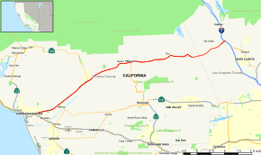 Map of southern California with SR 126 highlighted in red | ||||
| Route information | ||||
| Defined by Streets and Highways Code § 426 | ||||
| Maintained by Caltrans | ||||
| Length | 40.455 mi[1] (65.106 km) | |||
| Existed | 1934 – present | |||
| Major junctions | ||||
| West end |
| |||
| ||||
| East end |
| |||
| Location | ||||
| Counties | Ventura, Los Angeles | |||
| Highway system | ||||
| ||||

State Route 126 (SR 126) is a highway in Ventura and Los Angeles counties, California. The route runs from U.S. Route 101 in Ventura to Interstate 5 in Santa Clarita through the Santa Clara River Valley. The highway is an important connector highway in Ventura County, and serves as an alternate route into the Santa Clarita and San Fernando valleys, the High Desert of Antelope Valley, and Los Angeles.
Route description
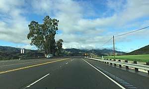
SR 126 generally follows the Santa Clara River through the valley, passing through the towns of Fillmore and Santa Paula. The freeway portion of the highway - called the Santa Paula Freeway - begins in Ventura at U.S. Route 101. It proceeds northeast through the city, interchanging with the western end of SR 118 at a grade-separated interchange. SR 126 then passes through the area of agriculture, orchards, and the Saticoy Oil Field to its northeast, continuing through Santa Paula, where it intersects SR 150, and the freeway portion terminates at Hallock Drive. SR 126 continues as a highway thereafter, known as Telegraph Road. This section extends through Fillmore as Ventura Street, where SR 126 meets SR 23. Following this, SR 126 as Telegraph Road encounters the community of Buckhorn, as well as the edge of Piru and the important historical Rancho Camulos.[2]
In Los Angeles County, SR 126 is known as Henry Mayo Drive. The highway continues east to an interchange with I-5. At this interchange the SR 126 designation terminates, and the road continues into Santa Clarita as Newhall Ranch Road.[3]
SR 126 is part of the California Freeway and Expressway System,[4] and is part of the National Highway System,[5] a network of highways that are considered essential to the country's economy, defense, and mobility by the Federal Highway Administration.[6] SR 126 is eligible to be included in the State Scenic Highway System,[7] but it is not officially designated as a scenic highway by the California Department of Transportation.[8]
History
Original plans
In 1958, the freeway was originally planned to follow along the northern banks of the Santa Clara River, connecting US 101 to US 99 (I-5 today) and US 6 (SR 14 today) through what is now Santa Clarita. In the mid 1960s, construction of the 4 lane freeway began immediately northeast of Oxnard, California at US 101 and immediately east of Santa Clarita, CA at US 6.
Freeway revolts
In the face of anti-development pressure from Ventura County citizens, and suffering from severe financial problems as a result of the 1971 Sylmar earthquake and the late-1970s California tax revolt, Caltrans abandoned its plans. The freeway, which by then had reached Santa Paula, California, terminates at a four-way intersection immediately east of the city. From there a 4 lane undivided highway continues on toward I-5. The eastern approach of SR 126 was abandoned midway through the interchange's construction at CA 14. Two long on-ramps and a large graded plateau are all that remain of the approach.
The only remnants of these plans are the two long ramps to and from the Antelope Valley Freeway at the Sierra Highway exit 6A in Santa Clarita and Newhall Ranch Road, a six to eight-lane divided local road continued from the current terminus of SR 126 at Interstate 5 and roughly follows the original 1958 route to just past Bouquet Canyon Road on the north side of the Santa Clara River.
1984 Summer Olympics
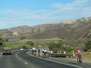
The 1984 Summer Olympics Organizing Committee was allowed to close the freeway portion between Ventura and Santa Paula for cycling practice for the 100 Kilometer Team Trials on two consecutive Thursdays.[9]
Cross Valley Connector
On 27 March 2010, the city of Santa Clarita completed the decade-long Cross Valley Connector (CVC) [10] project, which sought to connect SR 126 directly to SR 14 roughly along the original route alignment. The city-maintained route is named Newhall Ranch Road on the western segment, and Golden Valley Road on the eastern segment. The two segments meet at the intersection of Newhall Ranch Road and Golden Valley Road, where Golden Valley Road turns and continues north-east at a signaled intersection.
Today
In 2017, CalTrans began construction along the 1.75 mi eastern end of SR 126, upgrading the 6 lane divided highway to an 8 lane freeway. A new interchange replaced the four-way stop at Commerce Center Dr.[11]
Major intersections
Except where prefixed with a letter, postmiles were measured on the road as it was in 1964, based on the alignment that existed at the time, and do not necessarily reflect current mileage. R reflects a realignment in the route since then, M indicates a second realignment, L refers an overlap due to a correction or change, and T indicates postmiles classified as temporary (for a full list of prefixes, see the list of postmile definitions).[1] Segments that remain unconstructed or have been relinquished to local control may be omitted. The numbers reset at county lines; the start and end postmiles in each county are given in the county column.
| County | Location | Postmile [1][12][13] | Exit [14] | Destinations | Notes |
|---|---|---|---|---|---|
| Ventura VEN 0.00-R34.63 | Ventura | 0.00 | 1A | Access to US 101 south via Victoria Ave.; west end of SR 126; US 101 north exit 66A, south exit 66 | |
| 0.00 | 1B | Main Street (US 101 Bus.) | Westbound exit and eastbound entrance; former US 101 | ||
| 1.45 | 1C | Signed as exit 1 eastbound; signed as "Victoria Ave." only eastbound | |||
| 2.80 | 3 | Kimball Road | |||
| R5.03 | 5 | ||||
| | R8.91 | 9 | Briggs Road | ||
| Santa Paula | R10.38 | 10 | Peck Road | ||
| R11.37 | 11 | Palm Avenue | |||
| R12.04 | 12 | ||||
| R13.25 | East end of freeway | ||||
| Fillmore | 21.14 | ||||
| Los Angeles LA R0.00-R5.83 | | R4.89 | 13 | Commerce Center Drive | Interchange[15] |
| | R5.46 | 40 | Castaic Junction | Closed interchange; former US 99 | |
| Santa Clarita | R5.83 | — | Interchange; east end of SR 126; I-5 exit 172; road continues as Newhall Ranch Road | ||
1.000 mi = 1.609 km; 1.000 km = 0.621 mi
| |||||
See also

References
- 1 2 3 California Department of Transportation. "State Truck Route List". Sacramento: California Department of Transportation. Archived from the original (XLS file) on June 30, 2015. Retrieved June 30, 2015.
- ↑ Ventura County Street Atlas (Map). Thomas Brothers. 1998.
- ↑ Los Angeles County Street Atlas (Map). Thomas Brothers. 2008.
- ↑ California State Legislature. "Section 250–257". Streets and Highways Code. Sacramento: California State Legislature. Retrieved June 9, 2017.
- ↑ Federal Highway Administration (March 25, 2015). National Highway System: California (South) (PDF) (Map). Scale not given. Washington, DC: Federal Highway Administration. Retrieved September 30, 2017.
- ↑ Natzke, Stefan; Neathery, Mike & Adderly, Kevin (June 20, 2012). "What is the National Highway System?". National Highway System. Washington, DC: Federal Highway Administration. Retrieved July 1, 2012.
- ↑ California State Legislature. "Section 260–284". Streets and Highways Code. Sacramento: California State Legislature. Retrieved June 9, 2017.
- ↑ California Department of Transportation (September 7, 2011). "Officially Designated State Scenic Highways and Historic Parkways". Sacramento: California Department of Transportation. Retrieved September 30, 2017.
- ↑ Resolution 84-20, February 27. 1984, City Council of San Buenaventura
- ↑ Cross Valley Connector
- ↑ http://www.dot.ca.gov/d7/env-docs/docs/126_interchange_ISEA_reduced.pdf
- ↑ California Department of Transportation (July 2007). "Log of Bridges on State Highways". Sacramento: California Department of Transportation.
- ↑ California Department of Transportation, All Traffic Volumes on CSHS, 2005 and 2006
- ↑ California Department of Transportation, California Numbered Exit Uniform System, SR-126 Eastbound and SR-126 Westbound, accessed February 2008
- ↑ "QuickMap". Caltrans. State of California. Retrieved 13 December 2017.
External links
| Wikimedia Commons has media related to California State Route 126. |