Sélibaby
| Sélibaby | |
|---|---|
| Commune and town | |
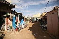 A view from a commercial street in Sélibaby | |
| Country |
|
| Region | Guidimaka Region |
| Area | |
| • Total | 2,000 km2 (800 sq mi) |
| Elevation | 62 m (203 ft) |
| Population (2013 census) | |
| • Total | 26,420 |
Sélibaby is a capital town and department of the Guidimaka Region, Mauritania. It is located at around 15°9′33″N 12°11′00″W / 15.15917°N 12.18333°W. It is divided into a number of "quartiers" which include "College", "Silo", 'Ferlo" , "nezaha" , "saada" , "el jedida" "Bambaradougou" amongst many others. Selibaby also has a regional hospital, funded by the Chinese government and partially staffed by Chinese doctors and is the headquarters of the regional director of health. Selibaby is a centre for NGOs who operate in the region.
Climate
In Selibaby, there is a Semi-arid climate with little rainfall. The Köppen-Geiger climate classification is BSh. The average annual temperature in Selibaby is 29.0 °C (84.2 °F). About 452 mm (17.80 in) of precipitation falls annually.
| Climate data for Selibaby | |||||||||||||
|---|---|---|---|---|---|---|---|---|---|---|---|---|---|
| Month | Jan | Feb | Mar | Apr | May | Jun | Jul | Aug | Sep | Oct | Nov | Dec | Year |
| Average high °C (°F) | 33.5 (92.3) |
36.0 (96.8) |
38.7 (101.7) |
40.7 (105.3) |
41.1 (106) |
38.6 (101.5) |
34.7 (94.5) |
33.0 (91.4) |
34.2 (93.6) |
36.9 (98.4) |
36.3 (97.3) |
33.1 (91.6) |
36.4 (97.5) |
| Average low °C (°F) | 15.5 (59.9) |
17.3 (63.1) |
20.6 (69.1) |
24.1 (75.4) |
26.2 (79.2) |
26.2 (79.2) |
24.6 (76.3) |
23.7 (74.7) |
23.5 (74.3) |
22.5 (72.5) |
19.0 (66.2) |
16.5 (61.7) |
21.6 (71) |
| Average precipitation mm (inches) | 0 (0) |
1 (0.04) |
0 (0) |
0 (0) |
3 (0.12) |
48 (1.89) |
109 (4.29) |
157 (6.18) |
109 (4.29) |
23 (0.91) |
1 (0.04) |
1 (0.04) |
452 (17.8) |
| Source: Climate-Data.org,Climate data | |||||||||||||