São Mateus (Madalena)
| São Mateus | ||
| Civil Parish | ||
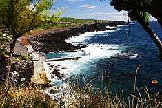 The old fishing port of São Mateus, with view to São Caetano, on the island of Pico | ||
|
||
| Official name: Freguesia de São Mateus | ||
| Name origin: Portuguese for Saint Matthew | ||
| Country | ||
|---|---|---|
| Autonomous Region | ||
| Island | Pico | |
| Municipality | Madalena | |
| Localities | Areiro, Badgaço, Canada Nova, Gingeira, Grotas, Grotas de Cima, Mata, Paço, Ponta da Calheta, Porto Novo, Porto de São Mateus, Pontinha, Relvas, Rua dos Caldeirões | |
| Rivers | Ribeira da Calheta, Ribeira das Grotas, Ribeira dos Bodes | |
| Center | São Mateus | |
| - elevation | 75 m (246 ft) | |
| - coordinates | 38°26′1″N 28°27′18″W / 38.43361°N 28.45500°WCoordinates: 38°26′1″N 28°27′18″W / 38.43361°N 28.45500°W | |
| Highest point | Mount Pico | |
| - elevation | 2,351 m (7,713 ft) | |
| - coordinates | 38°28′19″N 28°51′50″W / 38.47194°N 28.86389°W | |
| Lowest point | Sea level | |
| - location | Atlantic Ocean | |
| - elevation | 0 m (0 ft) | |
| Area | 17.37 km2 (7 sq mi) | |
| - urban | .64 km2 (0 sq mi) | |
| Population | 772 (2011) | |
| Density | 44/km2 (114/sq mi) | |
| LAU | Junta Freguesia | |
| - location | Estrada Regional | |
| - coordinates | 38°26′3″N 28°27′29″W / 38.43417°N 28.45806°W | |
| President Junta | Paulo Luis Goulart Machado (PS) | |
| Timezone | Azores (UTC-1) | |
| - summer (DST) | Azores (UTC0) | |
| Postal Zone | 9950-521 | |
| Area Code & Prefix | (+351) 292 XX XX XX | |
| Demonym | São-mateusense | |
| Patron Saint | São Mateus | |
 | ||
| Wikimedia Commons: São Mateus (Madalena do Pico) | ||

São Mateus is a civil parish along the southwestern coast of the municipality of Madalena on the island Portuguese island of Pico, in the archipelago of the Azores. The population in 2011 was 772,[1] in an area of 17.37 km².[2]
History
It is known, from oral investigations, that one of the first civil parishes created on the island of Pico was dedicated to the apostle Mathew, and which extended along the southern coast in an area considerably larger than today's limits.[3] It was, then, part of the locality of Arruda, its centre 12 kilometres (7.5 mi) from Lajes, and whose name was derived from a medicinal plant discovered in the region.[3]
Geography
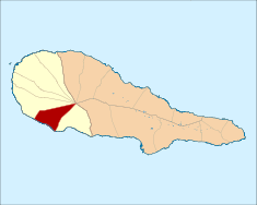
Connected to the two principal centers (Madalena on the west coast and Lajes on the south coast) by the Regional E.R.1-1ª roadway, the parish is wedged between the parishes of São Caetano and Candelária. The pie-shaped parish extends from the southern coast to the interior, sloping from rugged cliffs to the mountainous summit of Ponta do Pico. While farmlands and settlements occupy most of the areas along the roadways, the dense forest occupies the majority of its territory.
In addition to the parish center of São Mateus (location of the primary school, commercial businesses and civil government), located near the São Caetano border, the coastal village of Arieiro in the southwest corner and the interior hamlet of Ginjeira, are the predominant rural agglomerations.
Architecture
- Chapel of the São Mateus Cemetery (Portuguese: Capela do Cemitério de São Mateus), located on the Rua da Boa Vista and constructed in the 19th century (1890), the cemetery consists of a Baroque-style facade with arched doorway, flanked by two rounded windows, preceded by the long wall corridors of the cemetery and Gothic-like entrance gate.
- Hermitage of Nossa Senhora da Conceição (Portuguese: Ermida de Nossa Senhora da Conceição), constructed in 1753, consisting of a single nave buildings with simple triangular frontspeice surmounted by cross. Alongside is a complimentary simple bell-tower with two rounded-arch bellrey over rectangular doorway.
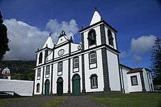
- Church of Bom Jesus Milagroso (Portuguese: Sanctuário do Bom Jesus Milagroso de São Mateus/Igreja Parochial de São Mateus), often believed to be dedicated to Saint Mathew, the parochial church in this parish is actually dedicated to the Miraculous Jesus Christ', its present facade completed in 1842.
References
- Notes
- Sources
- Madruga, Manuel Alexandre (December 1957), "A Freguesia de S. João Baptista da Ilha do Pico na Tradição Oral dos Habitantes", Boletim do Núcleo Cultural da Horta (in Portuguese), 1 (2), pp. 143–168
|access-date=requires|url=(help)