São João del-Rei Airport
| Prefeito Octávio de Almeida Neves Airport Aeroporto Prefeito Octávio de Almeida Neves | |||||||||||
|---|---|---|---|---|---|---|---|---|---|---|---|
 | |||||||||||
| Summary | |||||||||||
| Airport type | Public | ||||||||||
| Operator | Socicam | ||||||||||
| Serves | São João del-Rei | ||||||||||
| Elevation AMSL | 948 m / 3,110 ft | ||||||||||
| Coordinates | 21°05′11″S 044°13′35″W / 21.08639°S 44.22639°WCoordinates: 21°05′11″S 044°13′35″W / 21.08639°S 44.22639°W | ||||||||||
| Map | |||||||||||
 JDR Location in Brazil | |||||||||||
| Runways | |||||||||||
| |||||||||||
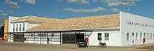
Prefeito Octávio de Almeida Neves Airport (IATA: JDR, ICAO: SNJR) is the airport serving São João del-Rei, Brazil. The airport is named after a former Mayor of São João del-Rei.
It is operated by Socicam.
History
On March 7, 2012, because of safety concerns, the National Civil Aviation Agency of Brazil (ANAC) imposed operational restrictions related to scheduled flights on the airport until irregularities are solved. General aviation operations were not affected.[3]
Airlines and destinations
Currently no scheduled flights operate at this airport.
Access
The airport is located 8 km (5 mi) from downtown São João del-Rei.
See also
References
- ↑ "São João del-Rei Airport Information". World Aero Data.
- ↑ "Lista de aeródromos públicos" (in Portuguese). ANAC.
- ↑ "Decisão n. 22 de 7 de março de 2012" (PDF) (in Portuguese). ANAC. March 7, 2012. Archived from the original (PDF) on March 3, 2016. Retrieved March 21, 2012.
External links
- Airport information for SNJR at World Aero Data. Data current as of October 2006.Source: DAFIF.
- Airport information for SNJR at Great Circle Mapper. Source: DAFIF (effective October 2006).
- Current weather for SNJR at NOAA/NWS
- Accident history for JDR at Aviation Safety Network
This article is issued from
Wikipedia.
The text is licensed under Creative Commons - Attribution - Sharealike.
Additional terms may apply for the media files.