Russell Mountain
| Russell Mountain | |
|---|---|
 Russell Mountain | |
| Highest point | |
| Elevation | 1,726 ft (526 m) |
| Coordinates | 37°34′23″N 90°41′43″W / 37.57306°N 90.69528°WCoordinates: 37°34′23″N 90°41′43″W / 37.57306°N 90.69528°W [1] |
| Geography | |
| Location | Iron County, Missouri, U.S. |
| Parent range | Saint Francois Mountains |
| Topo map | USGS Ironton |
Russell Mountain is a summit in Iron County in the U.S. state of Missouri.[1] Russell Mountain lies just east of Taum Sauk Mountain and Missouri Route CC provides access to the two peaks from combined Missouri routes 21 and 72 to the east. The town of Ironton is about six miles to the northeast. The Tom Sauk Trail traverses the Russell Mountain ridge.[2]
Russell Mountain most likely has the name of Giles Russell, a businessperson in the local mining industry.[3]
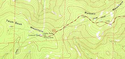
USGS Topographic map of the Taum Sauk and Russell Mountain area
References
- 1 2 U.S. Geological Survey Geographic Names Information System: Russell Mountain
- ↑ Ironton, Missouri, 7.5 Minute Topographic Quadrangle, USGS, 1968
- ↑ "Iron County Place Names, 1928–1945 (archived)". The State Historical Society of Missouri. Archived from the original on 24 June 2016. Retrieved 12 October 2016.
This article is issued from
Wikipedia.
The text is licensed under Creative Commons - Attribution - Sharealike.
Additional terms may apply for the media files.