Russell Fork
| Russell Fork | |
|---|---|
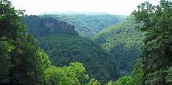 Russell Fork flowing through Breaks Interstate Park | |
| Country | United States |
| Physical characteristics | |
| Main source | Virginia |
The Russell Fork[1] is a 51.9-mile-long (83.5 km)[2] tributary of the Levisa Fork in southwestern Virginia and southeastern Kentucky in the United States. Known for its whitewater, it rises in the Appalachian Mountains of southwest Virginia, in southern Dickenson County, and flows north through the town of Haysi, Virginia, the Breaks Interstate Park, and the town of Elkhorn City, Kentucky, in Pike County, where it flows into the Levisa Fork which, together with the Tug Fork, form the Big Sandy River.
See also
References
- ↑ U.S. Geological Survey Geographic Names Information System: Russell Fork, 1975 Board on Geographic Names decision
- ↑ U.S. Geological Survey. National Hydrography Dataset high-resolution flowline data. The National Map, accessed June 13, 2011
- USGS Hydrologic Unit Map - State of Virginia (1974)
- Salmon, Emily J.; Edward D. C. Campbell, Jr., eds. (1994). The Hornbook of Virginia History (4th ed.). Richmond, VA: Virginia Office of Graphic Communications. ISBN 0-88490-177-7.
External links
Coordinates: 37°24′24″N 82°26′25″W / 37.40677°N 82.44015°W
This article is issued from
Wikipedia.
The text is licensed under Creative Commons - Attribution - Sharealike.
Additional terms may apply for the media files.