Russell, North Dakota
| Russell, North Dakota | |
|---|---|
| Unincorporated community | |
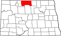
 Location of Russell, North Dakota | |
| Coordinates: 48°40′17″N 100°54′06″W / 48.67139°N 100.90167°WCoordinates: 48°40′17″N 100°54′06″W / 48.67139°N 100.90167°W | |
| Country | United States |
| State | North Dakota |
| County | Bottineau County |
| Township | Tacoma |
| Founded | 1905 |
| Incorporated | 1905 |
| Disincorporated | 1996 |
| Elevation | 1,467 ft (447 m) |
| Time zone | UTC-6 (Central (CST)) |
| • Summer (DST) | UTC-5 (CDT) |
| ZIP Code | 58762 |
| Area code(s) | 701 |
| FIPS code | 38-69180[1] |
| GNIS feature ID | 1031046[1] |
Russell is an unincorporated community in Bottineau County in the U.S. state of North Dakota.
| Historical population | |||
|---|---|---|---|
| Census | Pop. | %± | |
| 1910 | 161 | — | |
| 1920 | 119 | −26.1% | |
| 1930 | 94 | −21.0% | |
| 1940 | 70 | −25.5% | |
| 1950 | 51 | −27.1% | |
| 1960 | 25 | −51.0% | |
| 1970 | 14 | −44.0% | |
| 1980 | 18 | 28.6% | |
| 1990 | 14 | −22.2% | |
| U.S. Decennial Census[2] | |||
History
Russell was established as a farm post office in August 21, 1901 with the postmaster being Austin C. Russell. The post office was relocated in 1905 one mile to the northeast to the townsite on the Soo Line Railroad. Russell incorporated in 1905, and the town reached the peak population of 161 in 1910. Russell would later decline to a population of 14 in 1970.[3] Russell disincorporated on November 14, 1996.[1]
Geography
Russell is located at 48°40′17″N 100°54′06″W / 48.67139°N 100.90167°W (48.671389, -100.901667).[4]
References
- 1 2 3 "US Board on Geographic Names". United States Geological Survey. 2007-10-25. Retrieved 2008-01-31.
- ↑ United States Census Bureau. "Census of Population and Housing".
- ↑ Wick, Douglas A. "Russell (Bottineau County)". North Dakota Place Names. Retrieved 12 July 2017.
- ↑ "US Gazetteer files: 2010, 2000, and 1990". United States Census Bureau. 2011-02-12. Retrieved 2017-06-21.
This article is issued from
Wikipedia.
The text is licensed under Creative Commons - Attribution - Sharealike.
Additional terms may apply for the media files.