Russell, Georgia
| Russell, Georgia | |
|---|---|
| Census-designated place | |
 Russell | |
| Coordinates: 33°58′43″N 83°42′0″W / 33.97861°N 83.70000°WCoordinates: 33°58′43″N 83°42′0″W / 33.97861°N 83.70000°W | |
| Country | United States |
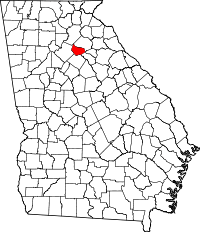
| State | Georgia |
| County | Barrow |
| Area | |
| • Total | 1.2 sq mi (3.1 km2) |
| • Land | 1.2 sq mi (3.1 km2) |
| • Water | 0 sq mi (0 km2) |
| Elevation | 980 ft (300 m) |
| Population (2010) | |
| • Total | 1,203 |
| • Density | 1,013/sq mi (391.3/km2) |
| Time zone | UTC-5 (Eastern (EST)) |
| • Summer (DST) | UTC-4 (EDT) |
| FIPS code | 13-67676[1] |
| GNIS feature ID | 0332944[2] |
Russell is an unincorporated community and census-designated place in Barrow County, Georgia, United States. The population was 1,203 at the 2010 census.[3]
Geography
Russell is located in central Barrow County at 33°58′43″N 83°42′0″W / 33.97861°N 83.70000°W.[4] It is bordered to the north and west by the city of Winder, the Barrow County seat.
According to the United States Census Bureau, the CDP has a total area of 1.2 square miles (3.1 km2), all land.[3]
References
- ↑ "American FactFinder". United States Census Bureau. Retrieved 2008-01-31.
- ↑ "US Board on Geographic Names". United States Geological Survey. 2007-10-25. Retrieved 2008-01-31.
- 1 2 "Geographic Identifiers: 2010 Demographic Profile Data (G001): Russell CDP, Georgia". U.S. Census Bureau, American Factfinder. Retrieved October 30, 2013.
- ↑ "US Gazetteer files: 2010, 2000, and 1990". United States Census Bureau. 2011-02-12. Retrieved 2011-04-23.
This article is issued from
Wikipedia.
The text is licensed under Creative Commons - Attribution - Sharealike.
Additional terms may apply for the media files.