Royalton, Pennsylvania
| Royalton, Pennsylvania | |
|---|---|
| Borough | |
 | |
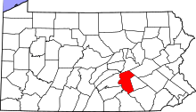
 Location in Dauphin County and the U.S. state of Pennsylvania. | |
 Royalton Location in Pennsylvania and the United States  Royalton Royalton (the US) | |
| Coordinates: 40°11′18″N 76°43′38″W / 40.18833°N 76.72722°WCoordinates: 40°11′18″N 76°43′38″W / 40.18833°N 76.72722°W | |
| Country | United States |
| State | Pennsylvania |
| County | Dauphin |
| Incorporated | 1892 |
| Government | |
| • Type | Borough Council |
| • Mayor | Sol Swartz |
| Area[1] | |
| • Total | 0.33 sq mi (0.87 km2) |
| • Land | 0.30 sq mi (0.78 km2) |
| • Water | 0.03 sq mi (0.08 km2) |
| Elevation | 305 ft (93 m) |
| Population (2010) | |
| • Total | 907 |
| • Estimate (2016)[2] | 1,019 |
| • Density | 3,363.04/sq mi (1,299.08/km2) |
| Time zone | UTC-5 (Eastern (EST)) |
| • Summer (DST) | UTC-4 (EDT) |
| ZIP code | 17057 |
| Area code(s) | 717 |
| FIPS code | 42-66560 |
| Website |
royaltonpa |
Royalton is a borough in Dauphin County, Pennsylvania, United States. As of the 2010 census the borough population was 907.[3] It is part of the Harrisburg–Carlisle Metropolitan Statistical Area. It shares its ZIP code with neighboring Middletown.
Geography
Royalton is located in southern Dauphin County at 40°11′18″N 76°43′38″W / 40.18833°N 76.72722°W (40.188325, -76.727280).[4] It is bordered to the southwest by the Susquehanna River, and to the west and north by Swatara Creek, across which is the borough of Middletown. Pennsylvania Route 441 (Canal Street) passes through the center of the borough, leading north into Middletown and southeast (downriver) 18 miles (29 km) to Columbia. Harrisburg, the state capital, is 11 miles (18 km) to the northwest (upriver).
According to the United States Census Bureau, the borough of Royalton has a total area of 0.34 square miles (0.87 km2), of which 0.30 square miles (0.78 km2) is land and 0.03 square miles (0.08 km2), or 9.48%, is water.[3]
Demographics
| Historical population | |||
|---|---|---|---|
| Census | Pop. | %± | |
| 1900 | 1,106 | — | |
| 1910 | 1,033 | −6.6% | |
| 1920 | 1,156 | 11.9% | |
| 1930 | 1,117 | −3.4% | |
| 1940 | 1,201 | 7.5% | |
| 1950 | 1,175 | −2.2% | |
| 1960 | 1,128 | −4.0% | |
| 1970 | 1,040 | −7.8% | |
| 1980 | 981 | −5.7% | |
| 1990 | 1,120 | 14.2% | |
| 2000 | 963 | −14.0% | |
| 2010 | 907 | −5.8% | |
| Est. 2016 | 1,019 | [2] | 12.3% |
| Sources:[5][6][7] | |||
As of the census[6] of 2010, there were 1083 people, 395 households, and 270 families residing in the borough. The population density was 2,774.8 people per square mile (1,062.3/km²). There were 415 housing units at an average density of 1,195.8 per square mile (457.8/km²). The racial makeup of the borough was 95.43% White, 0.52% African American, 0.31% Native American, 1.35% Asian, 0.83% from other races, and 1.56% from two or more races. Hispanic or Latino of any race were 2.49% of the population.
There were 395 households, out of which 29.1% had children under the age of 18 living with them, 50.6% were married couples living together, 13.9% had a female householder with no husband present, and 31.4% were non-families. 26.3% of all households were made up of individuals, and 7.1% had someone living alone who was 65 years of age or older. The average household size was 2.44 and the average family size was 2.90.
In the borough the population was spread out, with 22.9% under the age of 18, 7.3% from 18 to 24, 30.7% from 25 to 44, 27.2% from 45 to 64, and 11.8% who were 65 years of age or older. The median age was 38 years. For every 100 females, there were 85.9 males. For every 100 females age 18 and over, there were 91.2 males.
The median income for a household in the borough was $41,917, and the median income for a family was $44,821. Males had a median income of $34,688 versus $26,513 for females. The per capita income for the borough was $18,029. About 4.8% of families and 7.8% of the population were below the poverty line, including 15.6% of those under age 18 and 3.6% of those age 65 or over.
References
- ↑ "2016 U.S. Gazetteer Files". United States Census Bureau. Retrieved Aug 13, 2017.
- 1 2 "Population and Housing Unit Estimates". Retrieved June 9, 2017.
- 1 2 "Geographic Identifiers: 2010 Demographic Profile Data (G001): Royalton borough, Pennsylvania". U.S. Census Bureau, American Factfinder. Retrieved December 16, 2015.
- ↑ "US Gazetteer files: 2010, 2000, and 1990". United States Census Bureau. 2011-02-12. Retrieved 2011-04-23.
- ↑ "Census of Population and Housing". U.S. Census Bureau. Retrieved 11 December 2013.
- 1 2 "American FactFinder". United States Census Bureau. Retrieved 2008-01-31.
- ↑ "Incorporated Places and Minor Civil Divisions Datasets: Subcounty Resident Population Estimates: April 1, 2010 to July 1, 2012". Population Estimates. U.S. Census Bureau. Archived from the original on 17 June 2013. Retrieved 11 December 2013.