Royal National Rose Society Gardens
The Royal National Rose Society Gardens, also known as The Gardens of The Rose, are the gardens and headquarters of The Royal National Rose Society at Chiswell Green, near St Albans, Hertfordshire in the United Kingdom.
The Society's stated aim is to create a "living dictionary" of roses in the gardens, which contain 2,500 different rose cultivars among 15,000 rose bushes. The gardens are normally open to the public during the summer.
The Royal National Rose Society went into Administration on 15th May 2017. The Gardens are permanently closed. Former employees told the BBC they were not surprised the society had gone into administration after years of it struggling financially.
History
The Royal National Rose Society was established in 1876 and the gardens of the Rose was opened over 50 years ago by Mary, Princess Royal who was a Patron of the society at the time.[1]
The flowering seasons feature
- A rose collection, showing the history of the rose
- Roses in a garden setting showing different styles of planting
- Gardens to give inspiration for growing roses in small spaces
- New cultivar trials to provide an educational experience as well as being a pleasure to the eye when in full flower
- A much longer season of interest making extensive use of other plants which associate well with roses
- A cafe/tearoom is open, during the season, next to the main office
- Edland Pavilion within the gardens that is now licensed to conduct wedding ceremonies
Recent developments
The Royal Entomological Society refurbished the mansion adjacent to the Gardens and it has become the society's headquarters.
Butterfly World is adjacent to the gardens. Following a £27 million build, the project was launched in March 2008 at an event at the Royal Society in London. However, in December 2015 it was closed.[2]
Gallery
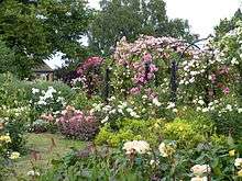 Royal National Rose Society Gardens in 2013
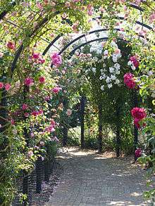
 Rose Arch at RNRS gardens of the Rose
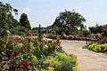 Path through Gardens of the Rose, RNRS
 Silver Birch and Rose Beds at Gardens of the Rose, RNRS
References
- ↑ Royal National Rose Society Gardens Pamphlet
- ↑ "BUTTERFLY WORLD TO CLOSE". 15 December 2015. Archived from the original on 7 August 2016. Retrieved 26 July 2016.
External links
Coordinates: 51°43′38″N 0°22′19″W / 51.727182°N 0.371943°W