Roy Mata
| UNESCO World Heritage site | |
|---|---|
 | |
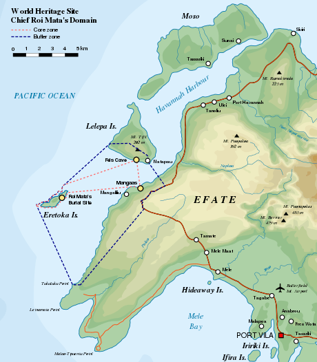
| Location | Vanuatu |
| Criteria | Cultural: (iii)(v)(vi) |
| Reference | 1280 |
| Inscription | 2008 (32nd Session) |
| Area | 886.31 ha (2,190.1 acres) |
| Buffer zone | 1,275.42 ha (3,151.6 acres) |
| Coordinates | 17°37′41.05″S 168°10′39.79″E / 17.6280694°S 168.1777194°ECoordinates: 17°37′41.05″S 168°10′39.79″E / 17.6280694°S 168.1777194°E |
 Location of Roy Mata in Vanuatu  Roy Mata (Oceania) | |
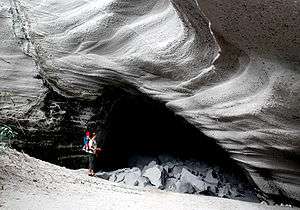
Roimata was a powerful 13th century Melanesian chief from what is now Vanuatu. His elaborate grave, containing the bodies of over 25 members of his retinue, was discovered by French archaeologist Jose Garranger in 1967 and inscribed on the World Heritage List in 2008. Garranger was able to locate the grave on Eretoka island by analyzing local folklore. According to legend, when Roy Mata conquered the land, his first goal was to unite the tribes.
His reign is reputed to have been a peaceful one. Roy Mata was fatally poisoned by his brother. His body was not buried in his homeland and his name was not used in future generations because the locals feared his spirit.
In 2008, three sites associated with Roy Mata, on the islands of Efate, Lelepa and Eretoka, were made UNESCO World Heritage Sites.[1][2]
.jpg) Chief Roimata's grave (Eratoka Island, 8 January 2017)
Chief Roimata's grave (Eratoka Island, 8 January 2017) Grave markers of Chief Roimata's wives (Eratoka Island, 8 January 2017)
References
- ↑ "Chief Roi Mata’s Domain", UNESCO
- ↑ "World Heritage Status set to ensure protection of Vanuatu's Roi Mata domain". Radio New Zealand International. July 9, 2008. Retrieved November 6, 2011.
- Vanuatu A to Z Retrieved August 25, 2006.
- "Roy Mata", Encyclopædia Britannica
- (in English) "Roymata - Ancient King of Vanuatu", Vanuatu Tourism Office