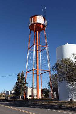
Roy, New Mexico
| Roy, New Mexico | |
|---|---|
| Village | |
 | |
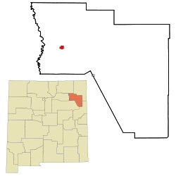 Location of Roy, New Mexico | |
 Roy Location in the United States | |
| Coordinates: 35°56′38″N 104°11′35″W / 35.94389°N 104.19306°WCoordinates: 35°56′38″N 104°11′35″W / 35.94389°N 104.19306°W | |
| Country | United States |
| State | New Mexico |
| County | Harding |
| Area | |
| • Total | 2.0 sq mi (5.3 km2) |
| • Land | 2.0 sq mi (5.3 km2) |
| • Water | 0.0 sq mi (0.0 km2) |
| Elevation | 5,896 ft (1,797 m) |
| Population (2010) | |
| • Total | 234 |
| • Estimate (2016)[1] | 224 |
| • Density | 120/sq mi (44/km2) |
| Time zone | UTC-7 (Mountain (MST)) |
| • Summer (DST) | UTC-6 (MDT) |
| ZIP code | 87743 |
| Area code(s) | 575 |
| FIPS code | 35-65070 |
| GNIS feature ID | 0894203 |
Roy is a village in Harding County, New Mexico, United States. The population was 234 at the 2010 census. The village has steadily been losing population, down from a peak of 1138 in 1940, but is still a major center for northeastern New Mexico.
Roy was a filming location in the 2009 comedy film Did You Hear About the Morgans?.
Geography
Roy is located at 35°56′38″N 104°11′35″W / 35.94389°N 104.19306°W (35.943890, -104.193025).[2]
According to the United States Census Bureau, the village has a total area of 2.0 square miles (5.2 km2), all of it land.
Notable residents
Demographics
| Historical population | |||
|---|---|---|---|
| Census | Pop. | %± | |
| 1920 | 564 | — | |
| 1930 | 713 | 26.4% | |
| 1940 | 1,138 | 59.6% | |
| 1950 | 1,074 | −5.6% | |
| 1960 | 633 | −41.1% | |
| 1970 | 476 | −24.8% | |
| 1980 | 381 | −20.0% | |
| 1990 | 362 | −5.0% | |
| 2000 | 304 | −16.0% | |
| 2010 | 234 | −23.0% | |
| Est. 2016 | 224 | [1] | −4.3% |
| U.S. Decennial Census[3] | |||
2000 Census
As of the census[4] of 2000, there were 304 people, 150 households, and 88 families residing in the village. The population density was 148.8 people per square mile (57.5/km²). There were 206 housing units at an average density of 100.8 per square mile (39.0/km²). The racial makeup of the village was 83.22% White, 1.97% Native American, 12.17% from other races, and 2.63% from two or more races. Hispanic or Latino of any race were 52.63% of the population.
There were 150 households out of which 20.0% had children under the age of 18 living with them, 45.3% were married couples living together, 10.0% had a female householder with no husband present, and 41.3% were non-families. 38.0% of all households were made up of individuals and 24.0% had someone living alone who was 65 years of age or older. The average household size was 2.03 and the average family size was 2.67.
In the village, the population was spread out with 17.8% under the age of 18, 5.3% from 18 to 24, 15.1% from 25 to 44, 27.3% from 45 to 64, and 34.5% who were 65 years of age or older. The median age was 52 years. For every 100 females, there were 96.1 males. For every 100 females age 18 and over, there were 98.4 males.
The median income for a household in the village was $21,111, and the median income for a family was $41,667. Males had a median income of $31,250 versus $20,179 for females. The per capita income for the village was $17,651. About 11.7% of families and 15.2% of the population were below the poverty line, including 25.0% of those under the age of eighteen and 13.7% of those sixty five or over.
Gallery
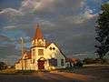 First Baptist Church - Roy
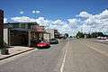 Hwy 39 - Richelieu St
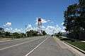 Hwy 39 - Richelieu St
References
- 1 2 "Population and Housing Unit Estimates". Retrieved June 9, 2017.
- ↑ "US Gazetteer files: 2010, 2000, and 1990". United States Census Bureau. 2011-02-12. Retrieved 2011-04-23.
- ↑ "Census of Population and Housing". Census.gov. Retrieved June 4, 2015.
- ↑ "American FactFinder". United States Census Bureau. Retrieved 2008-01-31.
External links
Municipalities and communities of Harding County, New Mexico, United States | ||
|---|---|---|
| Villages | 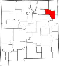 | |
| Unincorporated communities | ||
| Footnotes | ‡This populated place also has portions in an adjacent county or counties | |