Rouvre
| Rouvre | |
|---|---|
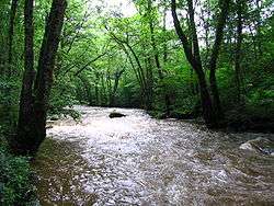 The river in woodland | |
| Country | France |
| Physical characteristics | |
| Main source |
Beauvain, Orne, Normandy 316 m (1,037 ft) |
| River mouth |
Orne at Ménil-Hubert-sur-Orne 63 m (207 ft) 48°50′50″N 0°23′03″W / 48.8471°N 0.3842°WCoordinates: 48°50′50″N 0°23′03″W / 48.8471°N 0.3842°W |
| Length | 42 km (26 mi) |
| Basin features | |
| Progression | Orne→ English Channel |
| Basin size | 309 km2 (119 sq mi) |
The Rouvre is a river in Normandy, in the Orne département, a tributary of the river Orne.
The river's source is in the commune of Beauvain, a few kilometres to the east of La Ferté-Macé. After crossing the Pays d'Houlme, it turns in a north-westerly direction to re-enter Norman Switzerland, and then in its last course of 15 km (9.3 mi) passes around Bréel.
The Rouvre then confluences into the Orne between the dam at Saint-Philbert-sur-Orne and Pont-d'Ouilly, and joins the Orne at Rouvrou (elevation 63 m (207 ft)).
This last part of its course is through small wooded gorges and its fast waters can make for good kayaking, when the water level permits, and fishing for brown trout. These gorges are home to animal and plant species such as pearl mussels and Osmond Royal (water-fern),[1] and one may occasionally see otters and salmon.
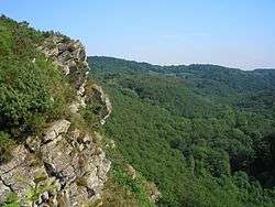
The river's environment makes it an important tourist attraction in Norman Switzerland, with its rural and fluvial environment, The viewpoint from the Rock of Oetre into the valley is of 118 m (387 ft) below, the steepest drop.
References
- ↑ Culpeper, Nicholas (1814). "Osmond Royal". Culpeper’s Complete Herbal and English Physician. Retrieved 2009-04-10.
External links
From the original article in French
French
- Page about the Rouvre, on a kayaking website
- Description of the Rock of Oetre, on the website of the Council-General of Orne
- CPIE des Collines normandes Association of environmental education, based at the Rouvre waterside, on the website of the 'House of River and Countryside'