New Brunswick Route 17
| ||||
|---|---|---|---|---|
| Route information | ||||
| Maintained by New Brunswick Department of Transportation | ||||
| Length | 148.4 km[1] (92.2 mi) | |||
| Existed | 1920s – present | |||
| Major junctions | ||||
| North end |
| |||
|
| ||||
| South end | Canada–US border at Saint-Leonard | |||
| Location | ||||
| Major cities | Kedgwick, Saint-Quentin | |||
| Highway system | ||||
|
Provincial highways in New Brunswick
| ||||

Route 17 is 148 kilometres (92 mi) long and runs from the Canada–US border in Saint-Leonard to Route 11 at Tide Head near Campbellton. Saint-Quentin and Kedgwick are other towns along the route. With the exception of those towns, the highway runs almost entirely through sparsely populated forest land. It is the only highway connecting northwestern New Brunswick with the province's north shore.
History
The purpose of the proposed was to improve deficiencies in the current Route 17 highway from north of Mud Brook to Hammond Gate Road area in Victoria County. The bypass goes north of the existing roadway and has been designed to meet present-day standards to improve safety, including flatter grades, creation of passing opportunities, upgrades to guiderail requirements and increased shoulder widths. The bypass is approximately 5 km in length. The project has been completed,
Gallery
 Route 17 in Whites Brook
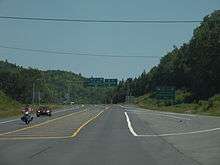 Route 11's junction with route 17 in Tide Head.
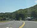 Route 17 in Glencoe
See also
References
- ↑ New Brunswick Department of Transportation: Designated Provincial Highways, 2003