Massachusetts Route 135
| ||||
|---|---|---|---|---|
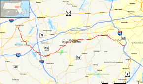 Map of eastern Massachusetts with Route 135 highlighted in red | ||||
| Route information | ||||
| Maintained by MassDOT | ||||
| Length | 29.53 mi[1] (47.52 km) | |||
| Major junctions | ||||
| West end |
| |||
| East end |
| |||
| Location | ||||
| Counties | Worcester, Middlesex, Norfolk | |||
| Highway system | ||||
| ||||

Route 135 is a state highway in eastern Massachusetts, running from U.S. Route 20 in Northborough east to Interstate 95 (Route 128) in Dedham. The first 13 miles (21 km) of the Boston Marathon, from Hopkinton to Wellesley, follow Route 135.
Route description
Route 135 begins at U.S. Route 20 in Northborough. The route follows a generally southeasterly path, interchanging with Route 9 approximately 1-mile (1.6 km) from its beginning. The route continues into Westborough, where it meets Route 30 at a rotary. Route 135 continues southeast, crossing underneath Interstate 90 and Interstate 495, but interchanging with neither. The route enters Hopkinton, and turns northeast at an intersection with West Main Street (access to I-495 is possible using this road). Not far down the road, Route 135 crosses Route 85, continues into Ashland and then into Framingham. In downtown Framingham, Route 135 crosses Route 126. Route 135 continues into Natick and crosses Route 27 in the center of town. The road continues into Wellesley, passing by the campus of Wellesley College before entering the town center. Route 135 and Route 16 meet at a 5-way intersection and run concurrently for a short distance. Route 135 splits off Route 16 and once again turns southeast onto Great Plain Avenue. The highway enters Needham, and splits off Great Plain Avenue towards Dedham. Upon entering Dedham, Route 135 officially terminates at Interstate 95.
The road that continues after the interchange (West St./Common St.) passes Northeastern University's Dedham campus and meets Route 109 approximately a half mile to the southeast, near Dedham Center.
History
Route 135 is one of the state's earliest highway routes established circa 1927. The route originally ran from Route 128 along Highland Avenue in Needham to Route 115 (now Route 9) in Westborough. Streets along this route included Great Plain Avenue and Wellesley Avenue in Needham, Central Street in Wellesley, East and West Central Streets in Natick, Waverly Street in Framingham, Union and West Union Streets in Ashland, Main Street and Wood Road in Hopkinton, and Hopkinton and Milk Roads in Westborough.[2] In 1931 the route was extended further west along Milk Road and then on South Street in Southborough to US Route 20.[3]. In 1932 the route was extended east taking over the original routing of Route 128 from Needham to the intersection of Route 3 (now Route 53 and Route 3A) in Quincy. Streets along this part of the route included Dedham Avenue in Needham, West and East Common Streets and High Street in Dedham, Milton Street in Canton. Canton Avenue and Centre Street in Milton, and Adams and Washington Streets in Quincy.[4] This part of route was truncated in the late 1950s after completion of the Route 128 expressway between Needham and Braintree made Route 135's routing redundant.
Major intersections
| County | Location | mi | km | Destinations | Notes |
|---|---|---|---|---|---|
| Worcester | Northborough | 0.00 | 0.00 | Western terminus of Route 135. | |
| Westborough | 2.6 | 4.2 | |||
| 4.2 | 6.8 | Rotary intersection. | |||
| Middlesex | Hopkinton | 6.4 | 10.3 | No access between I-90 and Route 135 | |
| 8.9 | 14.3 | No access between I-495 and Route 135 | |||
| 10.5 | 16.9 | ||||
| Framingham | 17.3 | 27.8 | |||
| Natick | 21.0 | 33.8 | |||
| Norfolk | Wellesley | 24.0 | 38.6 | 0.2 mile concurrency. | |
| Dedham | 29.53 | 47.52 | Eastern terminus of Route 135. I-95 / Route 128 Exit 17. West Street continues east to | ||
1.000 mi = 1.609 km; 1.000 km = 0.621 mi
| |||||
References
- ↑ Executive Office of Transportation, Office of Transportation Planning - 2005 Road Inventory
- ↑ Commonwealth of Massachusetts, Department of Public Works. 1929 Route Map and Detour Bulletin
- ↑ Commonwealth of Massachusetts, Department of Public Works. 1931 Road Map and Detour Bulletin
- ↑ Commonwealth of Massachusetts, Department of Public Works. 1932 Road Map and Detour Bulletin
External links
| Wikimedia Commons has media related to Massachusetts Route 135. |