Round Prairie, Oregon
| Round Prairie, Oregon | |
|---|---|
| Unincorporated community | |
 Round Prairie, Oregon  Round Prairie, Oregon | |
| Coordinates: 43°05′17″N 123°22′10″W / 43.08806°N 123.36944°WCoordinates: 43°05′17″N 123°22′10″W / 43.08806°N 123.36944°W | |
| Country | United States |
| State | Oregon |
| County | Douglas |
| Elevation | 568 ft (173 m) |
| Time zone | UTC-8 (Pacific (PST)) |
| • Summer (DST) | UTC-7 (PDT) |
| Area code(s) | 541 |
| GNIS feature ID | 1136712[1] |
Round Prairie is an unincorporated community in Douglas County, Oregon, United States. Round Prairie is located along Interstate 5 north of Myrtle Creek.
References
- ↑ "US Board on Geographic Names". United States Geological Survey. 2007-10-25. Retrieved 2008-01-31.
Municipalities and communities of Douglas County, Oregon, United States | ||
|---|---|---|
| Cities | 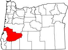 | |
| CDPs | ||
| Unincorporated communities | ||
| Indian reservations | ||
| Footnotes | ‡This populated place also has portions in an adjacent county or counties | |
This article is issued from
Wikipedia.
The text is licensed under Creative Commons - Attribution - Sharealike.
Additional terms may apply for the media files.