Roubidoux Formation
| Roubidoux Formation Stratigraphic range: Ordovician | |
|---|---|
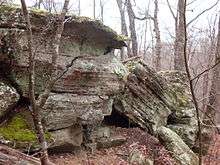 Outcrop of Roubidoux sandstone in the Missouri Ozarks | |
| Type | Formation |
| Underlies | Jefferson City Formation in the Missouri Ozarks |
| Overlies | Gasconade Formation[1] |
| Thickness | 100 to 300 feet[2] |
| Lithology | |
| Primary | Sandstone |
| Other | Dolostone, chert |
| Location | |
| Coordinates | 36°54′N 92°34′W / 36.90°N 92.57°WCoordinates: 36°54′N 92°34′W / 36.90°N 92.57°W |
| Region | Missouri, Virginia |
| Country | United States |
| Type section | |
| Named for | Roubidoux Creek, Texas and Pulaski counties, Missouri[2] |
The Roubidoux Formation is a geologic formation in the Ozarks of Missouri and in Virginia. It preserves fossils dating back to the Ordovician period.
See also
References
- ↑ Thompson, Thomas L., 2001, Lexicon of Stratigraphic Nomenclature in Missouri, Missouri Department of Natural Resources, Division of Geology and Land Survey, Report of Investigation Number 73, p 244-245
- 1 2 Thompson, Thomas L., Paleozoic Succession in Missouri: Part 2 Ordocician System, Report of Investigation No. 70, 1991, Missouri Department og Natural Resources, Rolla, MO, pp. 30-37
- Various Contributors to the Paleobiology Database. "Fossilworks: Gateway to the Paleobiology Database". Archived from the original on 31 July 2014. Retrieved 22 June 2014.
This article is issued from
Wikipedia.
The text is licensed under Creative Commons - Attribution - Sharealike.
Additional terms may apply for the media files.