Rotenboden railway station
Rotenboden | |||||||||||
|---|---|---|---|---|---|---|---|---|---|---|---|
 | |||||||||||
| Location |
Zermatt, Valais Switzerland | ||||||||||
| Coordinates | 45°59′04″N 07°45′55″E / 45.98444°N 7.76528°ECoordinates: 45°59′04″N 07°45′55″E / 45.98444°N 7.76528°E | ||||||||||
| Elevation | 2,815 m (9,236 ft) | ||||||||||
| Line(s) | Gornergrat railway | ||||||||||
| History | |||||||||||
| Opened | 20 August 1898 | ||||||||||
| Services | |||||||||||
| |||||||||||
| Location | |||||||||||
 Rotenboden Location within Switzerland | |||||||||||
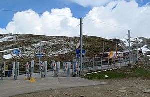
Rotenboden is a railway station on the Gornergrat railway, a rack railway which links the resort of Zermatt with the summit of the Gornergrat. The station is situated west of the Gornergrat, in the Swiss municipality of Zermatt and canton of Valais. At an altitude of 2,815 m (9,236 ft) above mean sea level, it is the second highest open-air railway station in Europe, after the Gornergrat railway station, on the same line.[1][2][3]
From the railway station a trail leads to the Monte Rosa Hut, across the Gorner Glacier.[4]
See also
References
- ↑ "Fahrplan Zermatt - Gornergrat (28.04.2014 - 06.06.2014)" [Timetable Zermatt - Gornergrat (28.04.2014 - 06.06.2014)] (in German). Gornergratbahn. Archived from the original on 2014-06-05. Retrieved 2014-05-30.
- ↑ "Betriebsdaten" [Operating data] (in German). Gornergratbahn. Archived from the original on 2014-06-02. Retrieved 2014-05-30.
- ↑ map.geo.admin.ch (Map). Swiss Confederation. Retrieved 2014-06-01.
- ↑ "The Walking Guide - Rotenboden to the Monte Rosa Hut". ski-zermatt.com. Retrieved 2014-06-01.
External links

This article is issued from
Wikipedia.
The text is licensed under Creative Commons - Attribution - Sharealike.
Additional terms may apply for the media files.